
With the right support and infrastructure, bikes can extend access to and from other modes like transit, serving an important last-mile connection. In fact, as transit ridership drops in the U.S., boosting bike infrastructure may help reverse that trend. A recent study by researchers at the University of Kentucky found the introduction of bike share increases rail ridership.
Bike riding is not only a healthy and affordable method of transportation, it’s also an important mode to link with public transit and extend mobility options. But bike-riding numbers in the U.S. are still quite low.
Dallas is one city that recently took a closer look at the bike-rail transit connection, with an eye to identifying where bike infrastructure could be improved.
Bike Infrastructure for “Complete Streets”
Many public officials at the local, regional, state and Federal levels are working to build better bike infrastructure. The concept of “complete streets” is now mainstream in transportation planning, as all levels of government strive to design and build streets that safely accommodate all transportation modes and users.
But the reality is that government agencies have a lot of competing priorities. Practically and financially, public agencies will never have sufficient resources to perfectly accommodate every type of user on every single road. However, they can, and should, prioritize complete networks for all modes, addressing coverage and gaps strategically.
We recently put together a report for Dallas officials interested in exploring options for evaluating bike infrastructure and prioritization.

Here is how we applied those metrics to the Dallas analysis.
1. Prioritize corridors for bike infrastructure. Our analysis helped us understand Dallas bicycle trip origin/destination patterns. This sort of analysis can be run in minutes for any type of geography in any location in the U.S. and Canada. The map below depicts the start locations of bicycle trips that end near light rail stations in downtown Dallas.
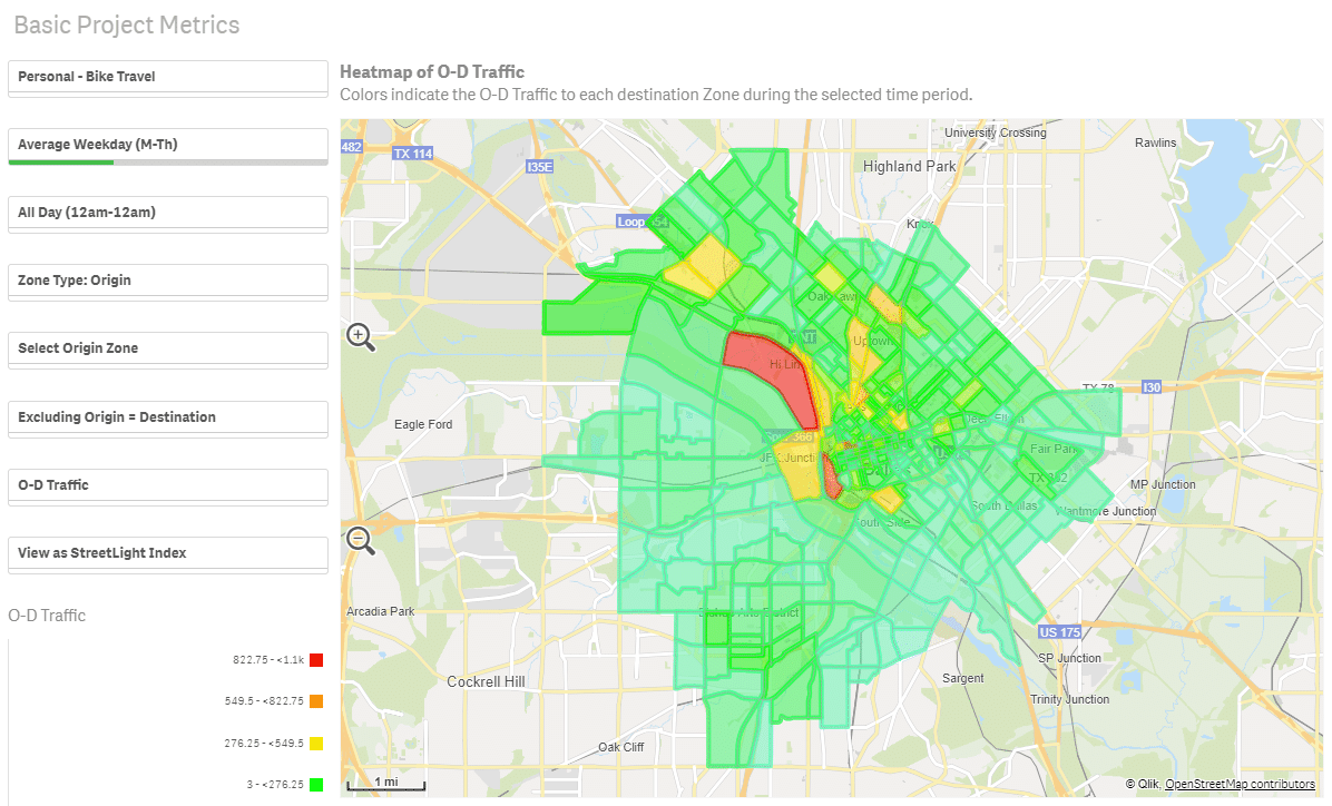
Fig 1: Heat map shows concentration of bike trip origins, with the red zone revealing a higher number of bike trip destinations.
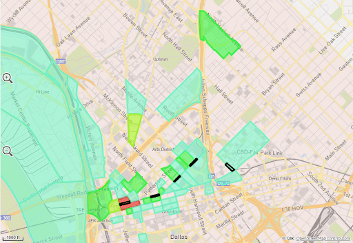
Fig 2: A closer look at bicycle trip origins that end near five light rail stations in downtown Dallas.
Knowing the origin and destination of bike trips helps transportation officials prioritize corridors for bike infrastructure. Additionally, a before/after analysis can be run to measure change in bike trips to/from light rail stations.
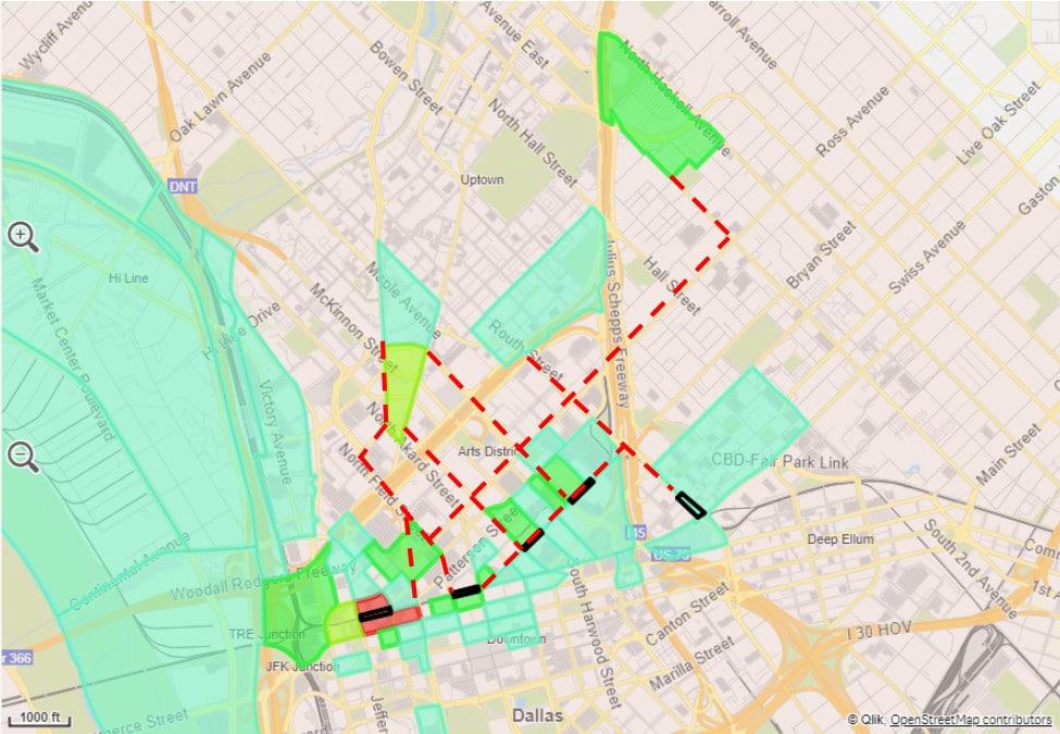
Fig 3: Proposed corridors to prioritize for bike infrastructure.
2. Understand characteristics of who is traveling by bicycle. Next, we applied a demographic overlay to our analysis. Not only could we see where and when trips are made, but who is actually making them. Understanding the demographic characteristics of transportation users is critical to designing a system that is accessible and useful to everyone.
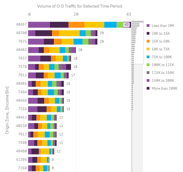
Figure 4: Income distribution for bicycle trips, summarized by origin.
3. Understand relative bicycle activity levels throughout the day. Finally, we analyzed levels of bicycle activity at specific locations throughout the day to identify peak bike commuting times. We did this because connections to light rail stations involve operational elements in addition to physical bike infrastructure. For example, traffic engineers can help ensure safe, efficient travel for bicyclists when timing traffic signals to accommodate busier travel times and corridors.
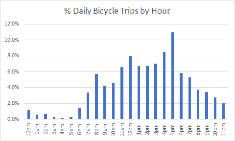
Fig 5: Percentage of bicycle trips by hour for Commerce Street in Dallas.
As Dallas works to build a world-class transportation system for current and future travelers, it will need high-fidelity data for all modes to make the right decisions. Regardless of the size or location of a city, planners across the country can rely on Big Data to inform recommendations and drive decisions.