
Data for Temporary Traffic Control in Seattle

It can happen at any time: A tanker truck hauling propane overturns on a major urban highway, completely closing it in both directions for eight hours and necessitating temporary traffic control. Vehicles and freight traffic are forced off the interstate and onto local roadways. Traffic is hampered for the remainder of the day as first responders work the accident, with the evening commute also severely impacted.
Wouldn’t it be great if traffic engineers had a data-driven plan in place for responding to emergency highway shutdowns with effective temporary traffic control? They can, with Big Data.
This propane truck accident actually happened one morning in February 2017, along I-5 southbound in Seattle (and there have been several other truck accidents since). We decided to analyze this real event to show how DOTs can plan for highway shutdowns, and why temporary traffic control based on data is more effective than ad-hoc rerouting.

Start With an Average Weekday Analysis
I-5 is an important north-south corridor through the downtown Seattle area, heavily used by both vehicle and freight traffic. To better understand where vehicles and trucks come from and go to, we ran an origin-destination (O-D) analysis in StreetLight InSight®.
We gathered traffic metrics for the average weekday morning, analyzing northbound and southbound trips during the peak commute period of 6:00 a.m. to 10:00 a.m.
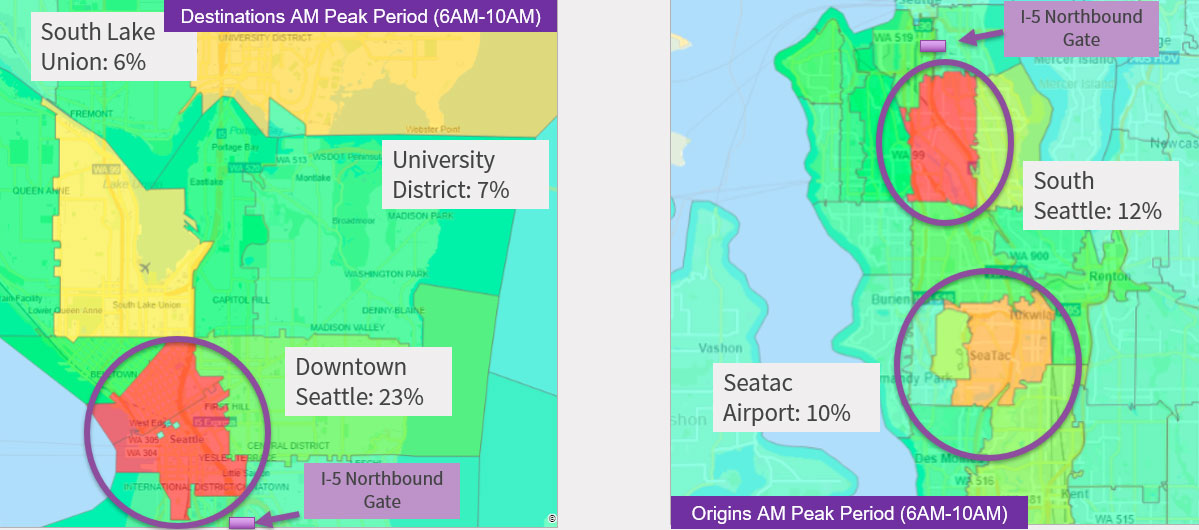
Figure 1: Top origins and destinations of trips on I-5 northbound.
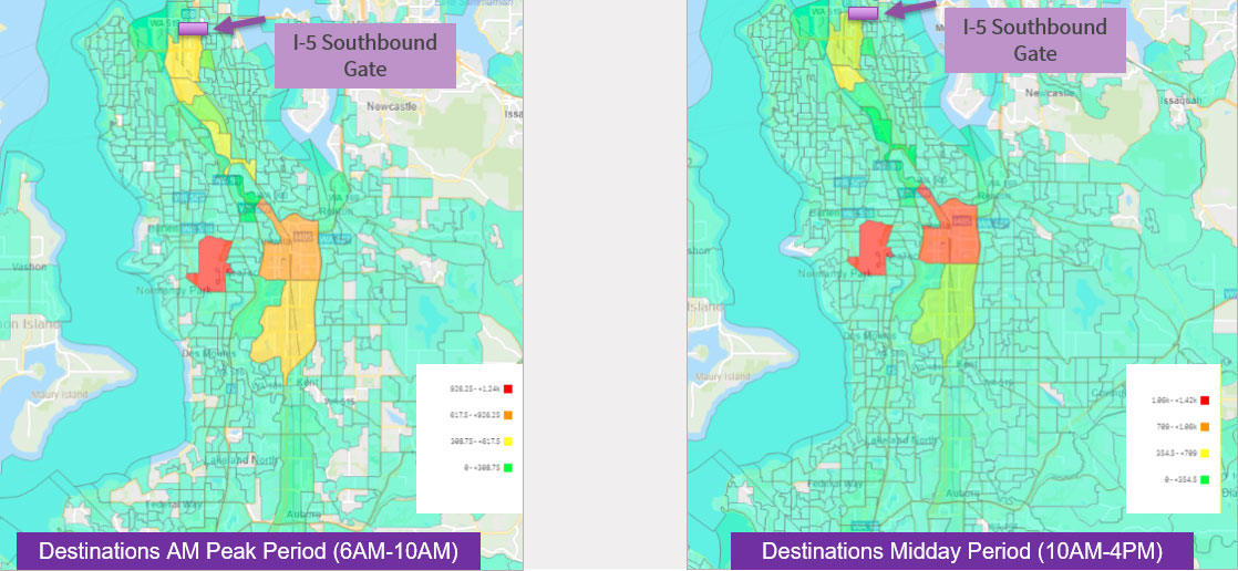
Figure 2: Destinations of southbound trips in the peak a.m. and midday periods.
The metrics showed that Seattle’s northbound streets, including the 99 corridor and 1st Street, are already heavily congested from 8:00 a.m. to 9:00 a.m. But other northbound corridors, including 4th Street, 15th Street and Martin Luther King, have capacity.
In contrast, southbound corridors are less congested during morning peak hours. Both I-5 and 99 south have less traffic than northbound, and parallel corridors through the city also have lighter levels of congestion compared to the northbound direction.
In our analysis we could see that 23% of all northbound trips end in downtown Seattle, 6% end in South Union Lake, and 7% end in the University of Washington area. Commercial destinations are mostly located north of Seattle, with the Boeing area as the destination for 3-5% of freight traffic.
StreetLight’s metrics also showed off-peak period average speeds from 11:00 a.m. to 4:00 p.m. Northbound congestion reduces during the midday period with speeds on local streets averaging 16-27 mph. I-5 at the incident location typically operates at an average speed of 31 mph.
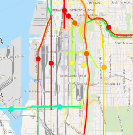
Figure 3: Heatmap indicating congested routes during Seattle’s morning commute period.
Average local roadway speeds northbound ranged from 16 – 22 mph in the morning peak period, and 16 – 27 mph during midday (at time of incident). The average I-5 northbound speed at the incident location is 27 mph in the morning peak period and 42 mph in the midday period.
Measure an Emergency’s Effects on Traffic
StreetLight’s historical database allowed us to go back in time to analyze the day of the accident, and how that upset the normal traffic flow. Not surprisingly, the accident affected both highway and local streets substantially in both directions, and StreetLight’s metrics showed us exactly how.
First, drivers heading northbound began diverting several miles from the incident, taking various routes as indicated in Figure 4.
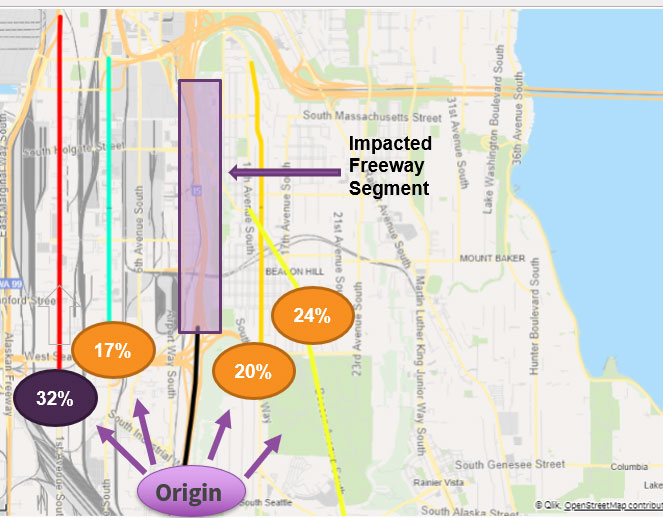
Figure 4: Focus on I-5 route choice at West Seattle bridge.
Southbound drivers beginning in downtown Seattle chose to reroute via I-99, 1st Street and 4th Street.
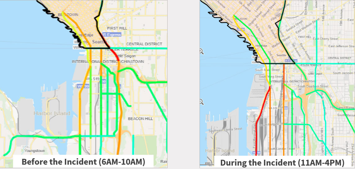
Figure 5: Route choice changes for southbound trips from downtown Seattle.
Of course the local roadways experienced a severe drop in speeds after the truck incident. Our report showed this drop particularly for Airport Way and 4th Street northbound. In addition, operational speeds on local roadways reduced by half in the northbound direction.
Data-Driven Temporary Traffic Control Options
For Seattle, there are several data-driven takeaways for morning I-5 temporary traffic control. First, for the higher congestion heading northbound, it makes sense to begin messaging about the incident further south, to Seattle Tacoma Airport. Many more alternative routes exist at this point.
Much of the southbound traffic (all day) is headed for the airport area where there is great transit alternative with the link light rail line. Martin Luther King is a potential reroute option if messaged early.
Truck reroutes are particularly challenging as most are traveling northbound to Boeing Field (3-5% of truck trips end at Boeing) and beyond. Perhaps 405 is a better alternative for long-haul truck trips.
When emergencies hit, first responders must act fast. Personnel on the scene are necessarily focused more on safety than on traffic optimization, but DOTs can support those efforts by stepping in with a solid plan. Big Data can inform data-driven temporary traffic control to enhance safety by rerouting more vehicles earlier, and keep traffic moving.