
Driving the Road Less (and Most) Traveled from DC to NYC

Last month, I started planning a long weekend trip from my hometown of Richmond, VA to New York City. One of the first questions that came to mind was what form of transportation I should take. I knew if I took a bus or car, I’d be certain to hit plenty of traffic to NYC on the way.
As a StreetLight employee, this got me thinking about how many drivers must travel between two of the busiest cities on the east coast, DC and NYC. For my driving trip, I assumed that most drivers would take I-95, but I wanted to avoid that traffic to NYC as much as possible.
I wondered how many other drivers also wanted to avoid I-95, and what alternate routes they were choosing to NYC. Luckily, with StreetLight’s new Top Routes analysis, I was able to find out in just 20 minutes and two steps. And it turned out my assumptions were wrong.
Hitting the Road with StreetLight InSight®
Running the analysis was easy. First, I uploaded shapefiles for DC and NYC.
Then, I ran a “Top Routes Between Origins and Destinations” analysis, set to the default options for day types, day parts, etc. — except I only ran data from October 2016, 2017, and 2018, because I wanted to exclude seasonal variation and focus on the time of year I would be traveling.
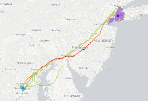
Figure 1: Traffic leaving DC for NYC flows primarily via I-95.
DC’s Top Traffic Routes to NYC
The analysis revealed that DC drivers leave through five main corridors:
- The Baltimore-Washington Parkway
- The John Hanson Highway
- The Kenilworth Avenue Freeway
- Connecticut Avenue
- New Hampshire Avenue
- Clara Barton Parkway Northwest
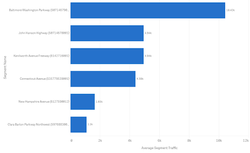
Figure 2: Drivers leaving DC primarily choose the Baltimore-Washington Parkway.
Most drivers take I-95 out of DC, as I anticipated. But I was surprised to see that the majority then shift quickly to the New Jersey Turnpike. Just take a look at where the Turnpike splits off from I-95, near Wilmington, Delaware, below. It turns out most people think like I do, and avoid I-95 to NYC. Maybe they’re even stopping at the best rest stop along I-95 just 15 minutes away.
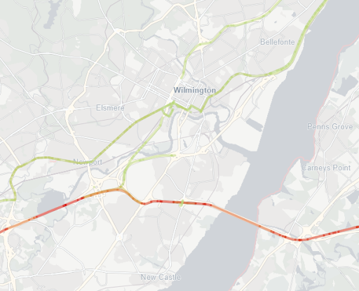
Figure 3: Heat mapping shows that south of Wilmington, most DC-to-NYC drivers shift from I-95 (green) to the New Jersey Turnpike (red/orange).
Once traffic gets to NYC, more drivers combined take bridges than tunnels. Despite that, the top route is the Lincoln Tunnel.
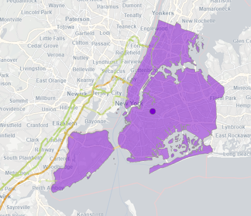
Figure 4: DC routes into NYC heat-mapped by traffic volume.
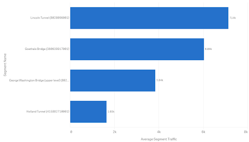
Figure 5: Most traffic to NYC from DC enters via the Lincoln Tunnel.
How the Rest of the US Enters NYC
Studying DC’s traffic to NYC made me curious about the routes drivers take from everywhere else in the U.S. After a quick “Top Routes for Zones” analysis, I found out that the most popular national routes for traffic to NYC are slightly different than the routes for DC drivers. They are, in this order:
- George Washington Bridge
- Lincoln Tunnel
- Holland Tunnel
- Long Island Expressway
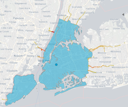
Figure 6: Heat map of national traffic into NYC.
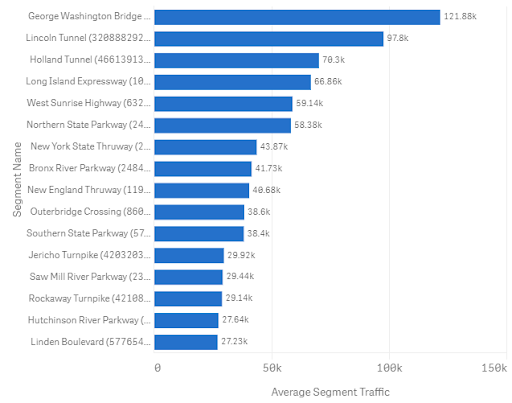
Figure 7: Drivers to NYC from the rest of the US prefer the George Washington Bridge.
Having access to information like this across a region is a great input into project prioritization and budget allocation.
Top Takeaways from Top Routes
This was just a cursory analysis to understand what I can expect from traffic to NYC on my drive — and I’ll definitely be taking I-95 instead of the New Jersey Turnpike.
But digging into this data on a more granular level could lead to macro and micro implications for these two cities (and any other large neighboring cities).
Further analysis can show, for example:
- Do these patterns change on the weekends, or over the summer?
- If one of these roads needs maintenance, how will a detour impact the adjacent roads?
- How will Amtrak’s new high-speed Acela Nonstop train impact these travel patterns?
- Will next year’s election have an impact on this traffic?
The questions are endless, but with StreetLight InSight, the answers are right at our fingertips.
