
New York Infrastructure: To BQE or Not to BQE

For decades, the Brooklyn-Queens Expressway (BQE) has existed as the Robert Moses-era eyesore of New York City. Moses, a mid-20th century “master builder,” planned the 16-mile stretch of roadway through Northern Brooklyn and Queens in the 1960s as an extension of Interstate 278, but years of congestion and deteriorating conditions have transformed the BQE into what is arguably America’s “least-loved highway.”
Reimagining the BQE and Nearby Community
As part of the Institute for Public Architecture’s 2020 Residency program, a group of Stantec engineers were faced with a daunting task: to research and envision a transportation system that could replace this anachronistic piece of highway infrastructure with community-focused mobility modes and other community amenities.
A quick Google search of the BQE will surface countless headlines pointing out failing infrastructure, including crumbling concrete, chipped paint, and overwhelming rust.
Further, inequities in the surrounding boroughs have been attributed to the BQE: adjacent communities are subject to air and noise pollution from the continuous traffic, while structural design has cut off access to the waterfront and other areas of public space.
Data-Driven Redesign
While many proposals to reimagine the BQE have been put forward, most of them include burying the highway in tunnels. Instead, the Stantec team imagined a stepwise approach that could gradually allow freight and passenger travel modes to shift while reclaiming space for the community.
Some alternate plans shifted freight movement from truck to barge to reduce congestion and pollution in the city, and Stantec wanted to specifically link that opportunity with proposals to rethink the BQE corridor altogether.
With the help of StreetLight Data, the team decided to look for opportunities within the existing geography of freight movement to begin enabling shifts to marine and rail-based movement. Stantec knew that to fix the problem, they’d have to understand it first—and the best way to do that was to dig into the data.
Redistributing Demand
While NYC’s commercial freight network is distributed across three main modes—truck, rail, and marine freight—that demand is disproportionately placed on high-polluting truck travel. Nearly 90% of the goods brought into New York City each year are moved in trucks, 20,000 of which travel along the BQE on a daily basis.
How can this demand be redistributed? Using StreetLight’s Origin-Destination Metric, Stantec was able to identify “hot spots” where truck trips along the BQE were coming from or going to, and determine their correlation to major industrial areas. This network was then analyzed alongside the local rail and marine freight networks to find significant route overlap—and opportunity for a gradual mode shift away from trucks.
The result? A data-driven, “future future” vision of the BQE that virtually eliminates freight truck travel, allowing for the introduction of new mobility modes and the creation of more than 90 acres of public space to serve as a community amenity. It’s a 21st-century overhaul of a 20th-century problem.
To learn more about Stantec’s plan to revitalize the BQE, read our case study here.
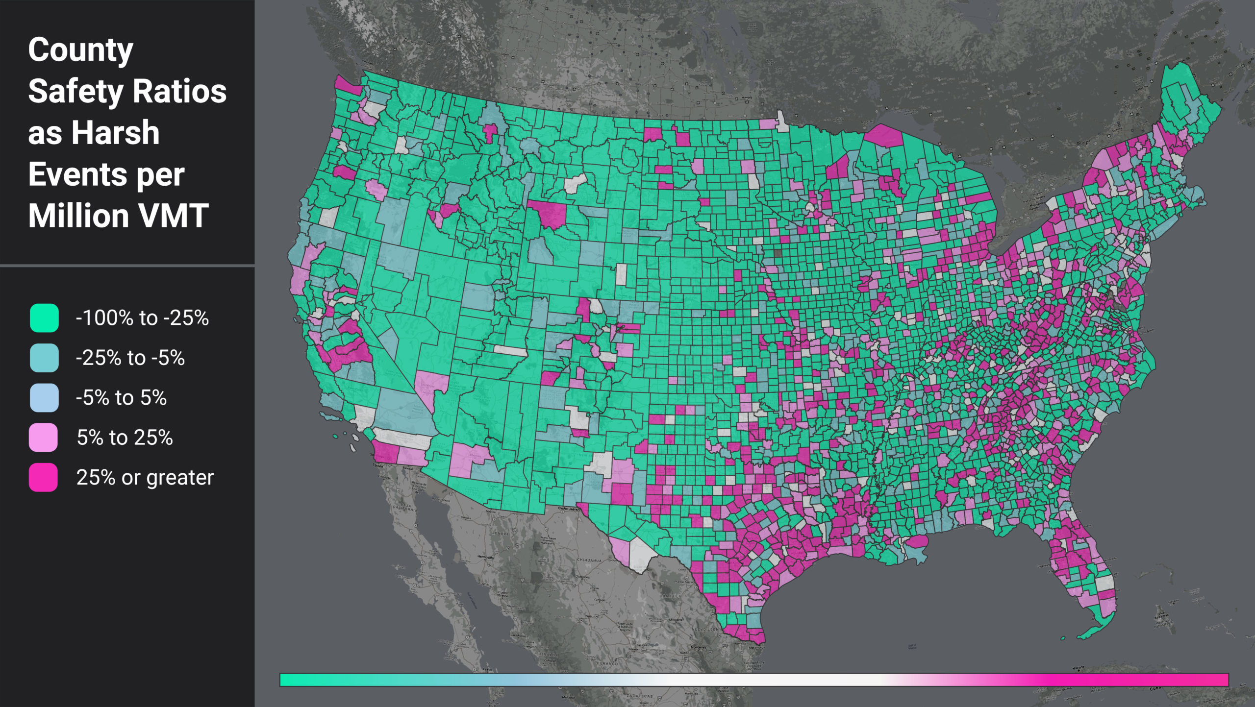
Figure 1: National heatmap of U.S. counties as measured by a ratio of harsh events (HE) per million VMT.
When we filter for the counties with higher-than-average HE per VMT, we see that certain regional patterns emerge. In Figure 1, areas around the Gulf Coast, the Appalachian region, and coastal/border counties light up. This pattern suggests further analysis into local factors such as topography, road curvature, percentage truck and pedestrian activity, and more to help us understand why these counties have such high HE per VMT ratios.
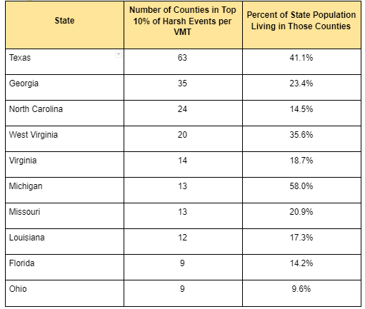
We also see that the top counties are confined to certain states. In fact, 13 states do not have a single county in the top 10%. For states with counties in the top 10%, some show up far more often than others. For example, 58% of Michigan’s population lives in counties with high rates of harsh braking events, while only 10% of Ohio’s population lives in similar high-risk counties.
Table 1: Top Counties by HE per VMT and Population Distributions
Calculating Population’s Effect
We wanted to assess if population was the real driver of a county’s higher-than-average HE per VMT, so we also analyzed harsh events per capita (HE per capita). We looked at each county’s HE per capita relative to the U.S. average (0.3), illustrated in Figure 2. Counties in green have lower than average HE per capita, while counties in blue have higher than average HE per capita.Summarized from “Private Versus Shared, Automated Electric Vehicles for U.S. Personal Mobility: Energy Use, Greenhouse Gas Emissions, Grid Integration, and Cost Impact” by Colin J. R. Sheppard, Alan T. Jenn, Jeffery B. Greenblatt, Gordon S. Bauer, and Brian F. Gerke, Environmental Science & Technology 55, no. 5 (March 2, 2021): 3229–39.