Public Data from NYCDOT Validates the Reliability of StreetLight’s Speed Metrics
Public Data from NYCDOT Validates the Reliability of StreetLight’s Speed Metrics
Access to accurate vehicle speed data is critical for effective road safety interventions, congestion mitigation, and more. We compared StreetLight’s speed metrics to data from New York City’s OpenData portal to ensure we’re delivering the most reliable insights.
To collect data on vehicle speeds, many agencies rely on permanent roadway sensors, speed cameras, or manual speed studies. But tight budgets and project timelines prevent the installation of sensors on every road, and manual studies only capture a small snapshot of roadway conditions, while also putting workers at risk.
Meanwhile, businesses and firms may not have access to the already limited speed data that is available via these methods, limiting their ability to make informed decisions about real estate, traffic operations, or events management.
For these and other reasons, many agencies, firms, and businesses turn to analytics platforms like StreetLight that leverage a big data approach to deliver vehicle speed metrics for any road, at any time. But when sourcing your data, it’s important to understand how reliable it is compared to more traditional ground truth methods.
Thanks to the City of New York’s OpenData portal, with publicly available vehicle speed data provided by NYCDOT, we were able to perform a validation of StreetLight’s speed data against New York City’s documented speeds. We’ll explain how our speed data is collected, how it compares to NYCDOT’s data, and what that means for your own vehicle speed analyses.
How NYCDOT Collects Speed Data
The speed data available in NYC’s OpenData portal is collected through E-ZPass readers located on approximately 110 road segments throughout the city. Vehicle speeds are calculated based on the travel time and distance between two E-ZPass readers.
This approach captures average vehicle speed in real time, and the portal is updated with the most recent data several times per day.1
How StreetLight Collects Speed Data
StreetLight’s Vehicle Speed metrics are derived from Aggregated GPS Data, which includes data from a blend of device navigation apps, traditional mobile data apps, and in-vehicle navigation apps.
This method has the advantage of strong penetration rates across various road sizes and regions for a highly representative sample, even on rural and lower-volume roads. StreetLight’s sample penetration rate averaged 27% nationally in 2023 and was observed as high as 40%+ in some locations.
To develop segment-level speed metrics, StreetLight maps this data onto the StreetLight InSight® Zone Library, derived from OpenStreetMap (OSM). Based on the length of the segment and how long it takes a vehicle to travel from one end to the other, we estimate the average vehicle speed along that segment.
For more information on how StreetLight collects, aggregates, and validates our vehicle speed metrics, you can download this white paper.
Comparing the Data: How Accurate Are StreetLight’s Speed Metrics?
To ensure an apples-to-apples comparison, StreetLight analysts first cleaned the NYCDOT data, removing certain obviously incorrect datapoints that may have been caused by malfunctioning E-ZPass readers. Next, the cleaned NYCDOT data was aggregated such that the mean speed could be calculated per segment by day of week and hour of day.
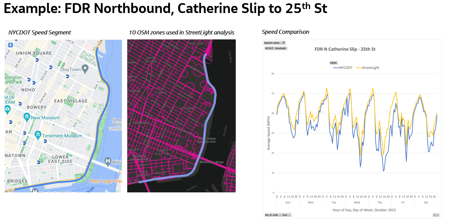
Using StreetLight’s Network Performance analysis, analysts obtained the average speeds of groups of OSM segments that aligned with NYCDOT’s segments, looking at data for October 2023. This allowed for a close comparison between StreetLight and NYCDOT average speeds on 11 NYCDOT segments.
In this example comparison for a portion of FDR Drive Northbound, analysts averaged vehicle speeds from 10 StreetLight OSM zones (middle) aligned to the corresponding NYCDOT segment (left). On the right, NYCDOT speeds by day and time are marked with a blue line, while StreetLight speeds are marked in yellow.
Because StreetLight’s OSM-based segments do not have a one-to-one correspondence with NYCDOT’s segments (which are derived based on the distance between E-ZPass readers), special care was taken to align StreetLight segments with those used by NYCDOT, but some discrepancies persist, which we will discuss further in the analysis below.
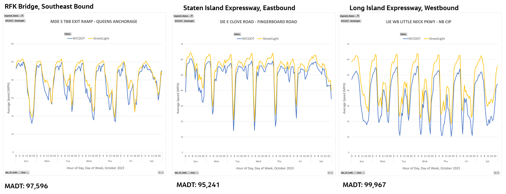
Speed comparisons by day of week and hour of day for RFK Bridge Southeast Bound (left), Staten Island Expressway Eastbound (middle) and Long Island Expressway Westbound (right) segments. Monthly Average Daily Traffic (MADT) for each segment is marked below its graph.
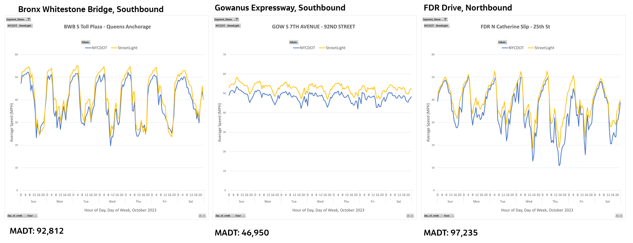
Speed comparisons for Bronx Whitestone Bridge Southbound (left), Gowanus Expressway Southbound (middle), and FDR Drive Northbound (right).
Speed comparisons for Bruckner Expressway Westbound (left), Brooklyn-Queens Expressway (BQE) Southbound between Atlantic and 9th St (middle), and the Brooklyn Battery Tunnel Eastbound (right).
The above nine segment analyses showed StreetLight speed metrics closely aligned with speed data reported by NYCDOT. Where the data differs, StreetLight speeds tend to be slightly higher than those reported by NYCDOT.
Overall, StreetLight’s daily and hourly speed variations for each segment also track closely with the NYCDOT data, indicating that StreetLight’s speed metrics deliver reliable insights for real-world applications like safety and congestion studies, which can save agencies the considerable cost of installing physical sensors.
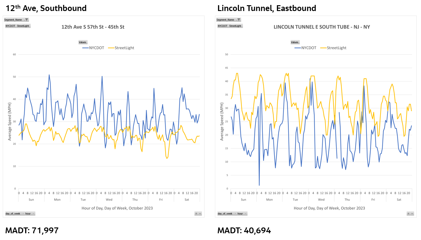
The two remaining segments (pictured below) display the greatest divergence between the StreetLight and NYCDOT datasets.
Speed comparisons for 12th Avenue Southbound (left) and Lincoln Tunnel Eastbound (right). These graphs show segments where StreetLight’s OSM zones could not be perfectly aligned to NYCDOT segments.
These discrepancies are likely caused, at least in part, by misaligned segment boundaries. As discussed above, sometimes StreetLight OSM zones could not be perfectly aligned to the NYCDOT segments.
In the case of 12th Avenue (AKA West Side Highway), this segment is part of a signalized corridor with closely spaced intersections, which could exacerbate the impact of the misaligned segments. Because the comparison segments do not have the same signalized-intersection approaches, this could lead to larger differences in average speed.
Despite these localized limitations in segment comparability, the overall results of our comparison show a high degree of alignment between StreetLight’s big data-based speed metrics and NYCDOT’s speed data derived from E-ZPass sensors.
More about StreetLight’s Vehicle Speed Data – Segment Speed and Spot Speeds
Because the vehicle speed metrics provided by StreetLight include average segment speeds, they can provide a helpful perspective, even for agencies that already collect speed data through physical sensors.
Unlike NYCDOT’s average segment speeds used in the above analysis, the speed data available to most agencies are spot speeds. Spot speeds capture vehicle speed at a specific location rather than the average vehicle speed along a whole segment.
Spot speeds and segment speeds each capture a different nuance of vehicle traffic, and comparing the two can help agencies better understand the causes of unsafe speeds or congestion, as well as their most effective solutions.
To ensure clients can take advantage of these nuanced speed insights, spot speeds are now available from StreetLight! To stay updated on all our product releases, consider subscribing to our newsletter.
1. City of New York. NYC OpenData. “DOT Traffic Speeds NBE.” https://data.cityofnewyork.us/Transportation/DOT-Traffic-Speeds-NBE/i4gi-tjb9/about_data
The Data Behind How Speed Cameras Curbed Crash Rates on One of Philadelphia’s Most Dangerous Roads
The Data Behind How Speed Cameras Curbed Crash Rates on One of Philadelphia’s Most Dangerous Roads
To fix deadly speeding on one of America’s most dangerous roads, Philadelphia installed speed cameras along eight sections of Roosevelt Blvd. Now, before-and-after analysis by StreetLight reveals how effective the strategy really was, and whether it could save lives in other cities.
Roosevelt Boulevard (US Route 1) in Philadelphia, PA has been dubbed one of America’s most dangerous roads. This twelve-lane highway is host to both local and commuter traffic, with at-grade express and local lanes traveling along its length.
Dozens of crashes resulting in severe injury or death occurred on the boulevard in 2020 alone, many of them involving pedestrians. [1] And because Northeast Philadelphia is home to a number of densely populated disadvantaged communities, the victims this boulevard claims are disproportionately people of color, whose communities have long been bisected by these twelve lanes of fast-moving vehicles.
In 2020, the city took measures to address the boulevard’s high crash rates, installing speed cameras along eight sections of Roosevelt Blvd. To understand how these cameras impacted safety conditions on the corridor, StreetLight used its transportation data platform to analyze vehicle speeds before and after the camera installation, looking at data from before COVID, during the pandemic, and as recently as 2024.
Then we investigated where high vehicle speeds persist on the boulevard, revealing potential locations for the next set of traffic calming interventions.
In this article, we’ll explore:
Roosevelt Boulevard’s speed problem
What Philadelphia is doing to reduce speeding
Whether speed cameras made Roosevelt Blvd safer (and how much)
How cities can choose the right traffic calming measures and evaluate their impact
Roosevelt Boulevard’s Speed Problem
At the heart of Roosevelt Blvd’s high crash rates is a history of dangerous vehicle speeds. Although the posted speed limit for much of the highway is 45 miles per hour, residents have complained that drivers on Roosevelt Blvd routinely exceed this limit. In one extreme case in 2013, four pedestrians, including three children, were struck and killed by two motorists traveling over 40mph above the posted speed limit. [2]
Data from PennDOT corroborates residents’ testimony, indicating that prior to 2020, 55% of crashes on the boulevard were attributed to speeding and aggressive driving.
A number of factors make the boulevard’s speed problem particularly deadly. Surrounding the 12-lane freeway, a growing population of Northeast Philadelphians generate significant pedestrian traffic as they access goods and services from the businesses that call Roosevelt Blvd home. Because many of these residents are from Disadvantaged Communities (DAC), they are also less likely to have access to a car, making them reliant on more vulnerable modes of transportation like walking and biking.
In the image below, StreetLight’s Justice 40 map layer highlights in purple the many Disadvantaged Community census tracts that surround Roosevelt Blvd.
Roosevelt Boulevard (in blue) is flanked by clusters of Disadvantaged Communities (in purple), shown by the StreetLight Insight® Justice 40 map layer.
Meanwhile, the roadway design has limited infrastructure designed to improve pedestrian safety or slow vehicles, such as pedestrian islands, bulb-outs, or signalized crossings, dramatically increasing the risk pedestrians face on the stroad.
Considering that pedestrians are five times more likely to die from crashes when cars are traveling 40 mph vs. 20 mph, according to data from the AAA Foundation, any vehicle exceeding the boulevards’ posted speed limit of 45 is likely to kill any pedestrian it strikes. [3]
Philadelphia’s Plan to Reduce Speeding
Now for the good news: a number of safety improvement projects are already in the works to address high crash rates on Roosevelt Blvd.
The City of Philadelphia has secured $10 million in state grants from PennDOT to be used on curb extensions, realignments to crosswalks, traffic lanes, and turning lanes, upgraded traffic signals, and other projects. Another $2 million will go toward the planning of future road design improvements as part of the city’s Route for Change program. [4]
While some of these improvements will be completed as far out as 2040, speed cameras offered the city a faster way to curb dangerous vehicle speeds in the short term.
In 2020, the City of Philadelphia, along with the Philadelphia Parking Authority, installed speed cameras along eight particularly dangerous stretches of Roosevelt Blvd to automate speed enforcement and ticket offenders.
Did Speed Cameras Make Roosevelt Blvd Safer?
Initial reports from the city have shown positive impacts from the speed cameras, with a 90% reduction in excessive speeding, a 36% drop in car crashes, and 50% fewer traffic deaths in the first seven months. [5]
How did speed cameras achieve such a dramatic effect, and will they continue to positively impact crash rates on the boulevard beyond their initial install? Furthermore, will the tactic be as effective in other cities, or along other roadways in Philadelphia’s high-injury network? Finally, are additional safety improvements needed to achieve the city’s Vision Zero goals for the boulevard?
To investigate these questions, we used StreetLight’s Network Performance tool to look back in time at speed conditions before cameras were installed, track the changes in average speeds (as well as rates of speeding) after cameras were installed, and follow up on where speeds are at now, in 2024, to identify where additional safety improvements may still be critical.
Establishing a Baseline
To understand how speed cameras impacted speeds on Roosevelt Blvd, we need to look back at speed conditions prior to their installation in June 2020. Because StreetLight’s Network Performance tool offers five years of comparable data, we can go all the way back in time to March 2019 to establish our baseline.
This timeframe is particularly useful as a baseline, because it allows us to look at typical speed conditions before the COVID pandemic disrupted traffic patterns across the country (we’ll look at how COVID impacted speeds in the next section).
To establish our baseline, we’ve chosen to analyze a typical Tuesday during the peak morning commute hours (8-9 a.m.). (Notably, this section of Roosevelt Blvd is relatively uncongested so even during peak hours, speeds are not tamped down significantly due to traffic.)
A map of average traffic speeds along Roosevelt Blvd. Higher speeds appear in red, while lower speeds appear in green.
In the map above, we can already see that average speeds exceed the 45 mph speed limit along many segments of the boulevard, and we can see where speeding is at its worst, with segments near Pennypack Park, Northeast Philadelphia Airport, and the Woodhaven Rd (PA-63) interchange standing out.
Speed distribution by hour of day and day of week in March 2019 on the Southbound express lane over Pennypack Creek. A beige line marks the mean speed, while the 85th percentile speed is shown with a golden line.
In the image above, we zoom in on a segment of Roosevelt where multiple fatal crashes have occurred — the Southbound express lane over Pennypack Creek. Looking at speed distribution by hour of day reveals that at 8 a.m. on an average Tuesday, the mean speed on this segment is 51 mph. Meanwhile, the 85th percentile speed (i.e. the speed that 85% of vehicles on the corridor are travelling at or below), which is commonly used to estimate rates of speeding, is 59 mph.
Bearing in mind that the posted speed limit is 45 mph along most of the boulevard, these figures reveal that speeding was indeed a significant issue in 2019. And that was before the COVID road safety crisis.
See how dangerous traffic speeds impact walking and biking in your region
It has now been well established that as roads emptied out during the March 2020 stay-at-home orders and subsequent rise in remote work and social distancing, vehicle speeds increased. Unsurprisingly, deadly crashes also spiked. This phenomenon is likely due to the relationship between road capacity and vehicle speed — as capacity increases, drivers tend to take advantage of the extra space to speed up. (This is also why road diets, with their reduction of lane capacity, are considered an effective safety intervention.)
Roosevelt Boulevard was no exception. Looking at the same deadly segment of roadway above Pennypack Creek, we can see that rates of speeding increased above their already high levels.
Speed distribution by hour of day and day of week in March 2020 on the Southbound express lane over Pennypack Creek.
During the peak a.m. hours, average speeds remain the same compared to 2019 (51 mph), but the 85th percentile speed has increased slightly to 60 mph. We also observe that speeds tend to spike even higher during non-peak hours, especially during the late evening.
To address this crisis, just a few months later, in June 2020, the City of Philadelphia installed speed cameras along eight particularly deadly stretches of Roosevelt.
Slowing Down: How Cameras Curbed Dangerous Speeding
Looking at average and 85th percentile speeds along Roosevelt Blvd in March 2022, our analysis corroborates the city’s initial reports of reduced speeding.
Speed distribution by hour of day and day of week in March 2022 on the Southbound express lane over Pennypack Creek, 21 months after speed cameras were installed.
After over a year of automated speed enforcement from the new cameras, average and 85th percentile speeds on the Southbound express lane over Pennypack Creek dropped significantly. The mean speed of 46 mph nearly matches the 45 mph posted speed limit. Meanwhile, the 85th percentile speed has been reduced to 52 mph – just 1 mph higher than the mean speed two years prior.
Following Up: Did Reduced Speeds Stick?
A look at recent data from March 2024 can help confirm whether the speed reduction observed in 2022 has continued, and where further safety interventions may still be critical to saving lives.
Speed cumulative frequency distribution from 2020 to 2024, highlighting the change in speed profile on the Southbound express lane over Pennypack Creek before and after the installation of speed cameras.
In the graph above, we chart speed distributions from each year analyzed (except 2019, which was identical to 2020 above the 30th percentile). The leftward shift highlights that overall speed continued to drop between 2022 and 2024. As of March 2024, a much larger percentage of vehicles are now traveling at or below the posted speed limit of 45 mph.
So has the boulevard’s speed problem been fixed? While rates of dangerous speeding have significantly dropped — and fatal crash rates along with them, according to city reports — some segments of the corridor may still need further intervention.
Segments of Roosevelt Blvd. with average traffic speed above 40 mph on a typical Tuesday between 8 a.m. and 9 a.m., March 2024.
Using the data trimming tool in StreetLight’s Network Performance product, we can zero in on sections of the boulevard where high-speed traffic still poses significant risk to pedestrians. The map above highlights in red the segments with average vehicle speeds above 40 mph during peak morning hours on an average Tuesday.
Although some of these segments have average vehicle speeds that fall below the 45 mph speed limit, we chose to highlight all segments with average speeds above 40 mph because these speeds fall within the range that is particularly deadly for pedestrians, according to the AAA Foundation.
At least nine highway segments of varying lengths emerge as potential candidates for further safety intervention. As we observed in 2019, segments near Pennypack Park, Northeast Philadelphia Airport, and the Woodhaven Rd (PA-63) interchange are among these high-speed areas.
Insights like these could help city officials determine where to prioritize state grant funds slated for additional traffic calming measures along the boulevard.
Spot Speeds on Roosevelt Boulevard
While the bulk of this analysis examines segment speeds, which are derived from a vehicle’s travel time from one end of a roadway segment to another (and the distance between those points), it can also be useful to examine spot speeds at specific locations along a corridor when evaluating potential safety improvements and the success of past projects.
Spot speeds measure a vehicle’s speed at a specific point in time and space, rather than the average speed across a given segment. This means spot speeds are particularly useful when analyzing safety or congestion on smaller roadway segments, such as a single intersection. In our case, they can also help shed light on exactly where drivers slow down and speed up, revealing whether and how quickly drivers speed back up after they’ve passed a speed camera.
In the data viz below, 15 spot speeds taken on a typical Tuesday between 8 and 9 a.m. in March 2024 show vehicles slow down after passing Pennypack Creek as they approach a speed camera located near Strahle Street. Drivers then speed up again as they approach Solly Ave, slowing once more as they approach an intersection with pedestrian crosswalks at Rhawn Street. These granular insights can help cities like Philadelphia determine the most effective safety measures to further the benefits of speed cameras.
Colored dots show spot speeds along Roosevelt Blvd. near Pennypack Creek on a typical Tuesday between 8 a.m. and 9 a.m., March 2024.
More About StreetLight’s Network Performance Tool
StreetLight’s Network Performance tool is ideal for before-and-after analyses like this. It offers five years of data comparability so cities can look back in time to understand how roadway conditions have changed over time, including traffic patterns from before COVID, which are often sought out as a baseline to understand “typical” past conditions. They can also analyze the impact of policy interventions to show the public the efficacy of their work.
Since many roadways lack permanent traffic counters (or only recently had counters installed), this ability to access historical traffic data for any road unlocks before-and-after analyses that would otherwise be impossible.
As we’ve demonstrated in our analysis above, agencies can use this Network Performance tool to proactively identify locations with a trend of excessive speeding, particularly where it overlaps with high crash rates, pedestrian/bicycle activity, or Justice40 communities.
With the data trimming option shown in the section above, agencies can easily pinpoint problematic road segments instead of relying on anecdotal observations about excessive speeding, or worse, waiting for the next crash to identify an unsafe traffic pattern. Likewise, this tool offers agencies the ability to monitor the impacts of changes in land use (e.g., new development), infrastructure (e.g. lane additions), traveler behaviors (e.g. work-from-home patterns due to COVID), traffic calming measures (e.g. speed limit reductions or speed cameras), and more.
The ability to analyze both segments speeds and spot speeds also offers added granularity that can be useful in understanding driver behaviors and diagnosing dangerous locations along a roadway.
Delaware Valley Regional Planning Commission. Crash Statistics for the DVRPC Region. https://www.dvrpc.org/webmaps/crash-data/
CBS News. “Philadelphia’s Roosevelt Blvd. Among most dangerous roads in US” July 10, 2023. https://www.cbsnews.com/philadelphia/video/philadelphias-roosevelt-blvd-among-most-dangerous-roads-in-us/
AAA Foundation for Traffic Safety. “Impact Speed and a Pedestrian’s Risk of Severe Injury or Death.” September 2011.
Michaela Althouse. Philly Voice. “Philadelphia gets $19.3 million for road safety projects from PennDOT, most directed to Roosevelt Boulevard work.” February 3, 2024. https://www.phillyvoice.com/roosevelt-boulevard-traffic-safety-projects-philadelphia-grants-penndot/
Philadelphia Parking Authority. Roosevelt Boulevard Automated Speed Camera Annual Report. April 2023. https://philapark.org/wp-content/uploads/2023-Speed-Camera-Report-Final-32023.pdf
Investigate local traffic trends with a free trial of StreetLight InSight®
Explore the resources listed above and don’t hesitate to reach out if you have any questions. We’re committed to fostering a collaborative community of transportation professionals dedicated to building a better future for our cities and communities.
America’s roads just keep getting wider. According to a Washington Post report, over a third of U.S. states spent more than $19 billion on expanding existing highways and road infrastructure in 2019. [1]
It’s a common way to attempt to curb the traffic congestion plaguing U.S. cities, but many transportation buffs say it’s the wrong approach. In fact, America’s road safety troubles may be directly related to its bloated urban corridors. The data appears to indicate that, in many cases, our roads don’t need to be fed more pavement — they need a diet.
The Federal Highway Administration (FHWA) points out that undivided four-lane roads — so ubiquitous in American cities — play host to a wide range of dangerous collisions, from lane-changing side swipes to bike and pedestrian crashes. These crashes are directly related to the volume and speed of traffic, but they’re also tied to the width and layout of the road. And, while it may seem counterintuitive, the path to increased safety without worsening congestion often lies in reducing lanes, rather than adding them, through a method called road diets. [2]
In this article, we’ll explore how road diets work to increase safety not only for vehicles, but also for pedestrians and cyclists. We’ll tackle the following:
What is a road diet?
Key safety considerations
How effective is a road diet?
Considering the alternatives
Finding the best approach with big data
So, What Is a Road Diet?
A road diet, or lane reduction, is a type of traffic calming measure designed to reduce speed and traffic congestion on an existing undivided roadway. Instead of expanding the existing road width with additional lanes, planners reduce the number of standard traffic lanes to make room for other types of lanes or road features.
Road diets are most common on four-lane highways. Typically, planners exchange the existing four driving lanes for a center left-turn lane flanked by two standard driving lanes and bike or pedestrian lanes. Other road diet examples include replacing two lanes with a tree-lined median or adding parking on the sides and narrowing existing lanes.
Photo source: Virginia DOT, reprinted in the U.S. DOT’s Road Diet Informational Guide
Whatever the specific approach, the overarching goal of a road diet is simple: to lower traffic speed and thus reduce the number and severity of crashes. In the process, this measure can also enhance the overall quality of life and appeal of an urban area by making more room for cyclists and pedestrians, expanding common areas, and even adding more green space to popular thoroughfares.
Key Safety Considerations
Understanding the value of road diets first requires an appreciation of just how threatening many of our busy four-lane, undivided roadways are. These popular road layouts are riddled with safety concerns for drivers, passengers, pedestrians, and cyclists alike. Before making any change to an established roadway, it’s essential to understand the dangers of the existing layout.
For Vehicles
In urban and suburban areas, four-lane, undivided highways are hot zones for vehicle-to-vehicle crashes. There are simply too many potential collision points for drivers to track. Such corridors are commonly home to all sorts of collisions:
Rear-end collisions from sudden stops or vehicles waiting to turn
Sideswipe crashes during lane changes
T-bone or angle collisions from cars turning left across oncoming traffic
Multi-car crashes at intersections
These collisions occur due to a range of factors, many of which can be addressed through road diets. High speed differential between lanes or intersecting streets can lead to sudden stops or miscalculations that result in collisions. Left turns across multiple lanes are also inherently dangerous. [2]
The specific traffic patterns and risks vary by location. When assessing the potential benefits of lane reductions, planners need data that allows them to analyze metrics like average speed, speed differentials, average traffic volumes, and typical turn counts at intersections.
For Pedestrians
As problematic as four-lane roads are for vehicle-to-vehicle crashes, they’re even more hazardous for pedestrians. Drivers hit and killed more pedestrians in 2022 than in any year since 1981, and these types of roads are at the center of many such collisions. [3] As one recent study revealed, 97% of the hot spots for pedestrian deaths in the U.S. are multi-lane roads. [4]
Pedestrians cross a multilane roadway.
Crashes on such roads occur for many reasons, from a lack of sidewalks to pedestrians misjudging oncoming vehicles when crossing multiple lanes. However, the central problem on wide urban streets is vehicle speed. Studies show that pedestrians are five times more likely to die from crashes when cars are traveling at 40 miles an hour than at 20 miles an hour.
Here again, data is crucial for determining the right solution. Understanding vehicle speeds, the volume of pedestrian traffic, and the frequency of pedestrian collisions can help planners assess whether a road diet — and which type — would provide an effective solution.
For Cyclists
According to the National Safety Council, more than 850 cyclists died in collisions with vehicles in 2021. [5] Many of these incidents were linked to unsafe road conditions. [6] The FHWA reports that the simple addition of a bike lane could reduce bike crashes by 49% on four-lane roads. [7]
Beyond being an argument for bike lane additions, this is a strong point in favor of considering road diets on cyclist-heavy city roadways. Road diets are designed to reduce traffic speed, and they can make room for more extensive road modifications such as protected bike lanes, which are physically separated from vehicle traffic.
See how dangerous traffic speeds impact walking and biking in your region
Overall, the data shows that road diets are often highly effective at increasing safety. Based on broad studies, the FHWA states that road diets can reduce crashes by between 19% and 47%. [2] In Seattle, a 2008 road diet reduced pedestrian collisions by 80%. The same project saw a 35% increase in cyclist traffic without any increase in bicycle-involved crashes.
To project the impact in a specific area, planners must account for various factors, particularly existing traffic volume. Lane reductions tend to be most effective on roads with between 8,000 and 20,000 average daily vehicles. [8]
Despite these benefits, many people are skeptical of road diets. In Los Angeles, the firefighters union recently launched a campaign against proposed road diets, claiming they would hinder emergency vehicles by increasing congestion. [9] Others argue they would slow down public transportation or simply divert heavy traffic elsewhere. [8]
Broadly speaking, the evidence to support these claims is slim. Although lane-reduction projects occasionally get pulled back, research shows that these road diet failures often occur due to a disconnection between public perception and reality. In other words — the project accomplishes its goal, even if the public thinks it’s not working.
That’s not to say these tactics are the right solution for every safety or traffic congestion problem. However, the evidence does indicate that when planners closely evaluate the many variables of a situation and decide to implement a road diet, the resulting safety enhancements are usually significant. [10]
Finding the Best Approach With Big Data
As noted, road diet success is much more likely with a deep analysis of traffic patterns. Understanding metrics like turning movement counts, average daily traffic volume and speed, speed differentials, and stopping frequency is essential for an accurate assessment of any potential project.
Big data platforms like StreetLight InSight® can expedite data collection when evaluating a potential road diet, providing detailed visualizations of traffic patterns and trends to help planners conduct a thorough road safety audit before making any decisions. This approach also makes the data collection itself safer because agency staff need not put themselves at risk to take manual counts along dangerous roadways. Furthermore, big data can provide a more complete view of roadway conditions than manual counts, which are usually limited to a small snapshot of traffic during peak driving hours on a particular day or a few days.
Many agencies are already using big data to evaluate potential road diets, as well as the success of past road diets. As the video below explains, Maine’s Department of Transportation used Streetlight tools to conduct a detailed analysis of its Bangor Street road diet proposal, filling in critical data gaps to understand turning movement counts, side-road traffic, and complex roundabout traffic flows.
Similarly, a StreetLight analysis of roadway capacity, vehicle speeds, routing patterns, and pedestrian activity suggested that a road diet on Oakland’s Grand Avenue could help address safety concerns without causing major congestion.
Grand Avenue, part of Oakland’s High Injury Network, could be a good candidate for a road diet treatment.
After implementing a road diet, big data transportation analytics also allow planners to easily measure any changes in traffic volumes, routing, safety, and critical metrics like Vehicle Hours of Delay (VHD). These insights simplify the process of assessing project potential and outcomes so planners can do their work more effectively.
For more information on how big data can help you find the best safety solutions for your streets, check out our Safety Data Handbook.
The Washington Post. “Infrastructure plan calls for fixing the nation’s existing roads. Some states are still focused on expansion.” https://www.washingtonpost.com/transportation/2021/05/23/highway-funding-infrastructure/
U.S. Federal Highway Administration. “Road Diet Informational Guide.” https://safety.fhwa.dot.gov/road_diets/guidance/info_guide/ch1.cfm
Journal of Transport and Land Use. “United States fatal pedestrian crash hot spot locations and characteristics.” https://jtlu.org/index.php/jtlu/article/view/1825
National Safety Council. “Bicycle Deaths.” https://injuryfacts.nsc.org/home-and-community/safety-topics/bicycle-deaths/#:~:text=In%202021%2C%20most%20deaths%20occurred,for%20Health%20Statistics%20mortality%20data
NPR. “More cyclists are being killed by cars. Advocates say U.S. streets are the problem.” https://www.npr.org/2022/05/25/1099566472/more-cyclists-are-being-killed-by-cars-advocates-say-u-s-streets-are-the-problem
U.S. Federal Highway Administration. “Bicycle Lanes.” https://highways.dot.gov/safety/proven-safety-countermeasures/bicycle-lanes
AARP. “Road Diets: A Livability Fact Sheet.” https://www.aarp.org/content/dam/aarp/livable-communities/livable-documents/documents-2014/Livability%20Fact%20Sheets/Road-Diets-Fact-Sheet.pdf
Los Angeles Times. “Firefighters launch campaign against Measure HLA, saying ‘road diets’ threaten safety.” https://www.latimes.com/california/story/2024-02-14/firefighters-launch-campaign-against-measure-hla
Scientific Research. “A Comprehensive Study of a Road Diet Implementation in the US and Abroad.” https://www.scirp.org/journal/paperinformation?paperid=127799#:~:text=The%20road%20diets%20were%20implemented,were%20implemented%20across%2066%20projects
See where vehicle speeds are putting all road users at risk
Explore the resources listed above and don’t hesitate to reach out if you have any questions. We’re committed to fostering a collaborative community of transportation professionals dedicated to building a better future for our cities and communities.
Part road, part street, the all-too-common stroad creates dangerous conditions, especially for non-motorists like pedestrians and cyclists. But what makes them so deadly, and how can data on traffic conditions help find and fix them?
In our increasingly suburbanized North American landscape, stroads are a cornerstone of the car-centric transportation paradigm. These bare-bones high-speed roadways are often devoid of any pedestrian- or bike-friendly infrastructure, subjecting drivers and non-motorists alike to dangerous conditions when commuting, shopping, or accessing essential services.
The drawbacks of the stroad stem from its hybrid nature: it attempts to connect people with key destinations (goods, services, city amenities) while also getting people from point A to B as quickly as possible. Far from being the best of both worlds, stroads often fail to accomplish either of these goals particularly well.
So what exactly is a stroad, and how can we make them less dangerous? In this article, we’ll discuss:
What is a stroad?
The problem(s) with stroads
How to fix stroads
Data to improve safety on stroads
What is a stroad?
The term “stroad” was first coined in 2011 by Charles Marohn to describe a roadway that combines elements of a street and a road.1 So what is the difference between a street and a road?
Streets are destinations — they provide access to goods, services, and recreation. They are often found in dense urban cores, especially downtowns, where shops, restaurants, parks, salons, doctors’ offices, and more dot every corner. These kinds of roadways typically have fewer lanes, slower traffic, and signalized crosswalks to accommodate plenty of foot traffic.
Streets typically have low speed limits, a low number of narrow lanes, ample sidewalks, and provide access to businesses, housing, and recreation.
Roads, by contrast, connect destinations to one another, prioritizing efficient traffic flow to get people from point A to point B. Consider a highway between cities, or between a downtown core and a suburb or exurb. These types of roadways typically have more lanes, higher-speed traffic, and limited to no access for non-motorists like walkers and bikers.
Roads typically have a larger number of wider lanes, higher speed limits, and limited to no access to non-vehicle traffic. They act as efficient connectors between destinations.
Stroads combine elements of both, acting as both destination and thoroughfare, which results in wide, high-speed roadways with sparse walking and biking infrastructure that are nevertheless crucial access points for goods, services, and recreation. These kinds of roadways are common around malls, strip malls, and other suburban hubs, but also frequently cut through urban cores — many downtown Main Streets are also stroads. Wherever they crop up, they usually feature speed limits between 20 and 50 miles per hour.2
When stroads manifest in the suburbs, it’s often because roads that were once used to connect suburban residents to the downtown core become attractive places for new shopping centers, restaurants, movie theaters, and more, boasting plenty of cheap space for sprawling supercenters and parking lots. Thus, roads that become host to these kinds of destinations are often doomed to morph into the dangerous stroad hybrid.
Stroads are also common in urban cores, especially where priority is placed on accommodating the high vehicle throughput that is common in these areas.
Stroads typically provide access to business and recreational destinations while featuring multiple wide lanes, higher traffic speeds, and minimal infrastructure for non-motorists.
The problem(s) with stroads
In addition to being dangerous, stroads also have other negative impacts on public health and the local economy.
Why are stroads dangerous?
As mentioned above, stroads lack many of the necessary features that make streets safe for walking and biking, such as signalized crosswalks, protected bike lanes, slow vehicle speeds, and short crossing distances.
But it’s not just Vulnerable Road Users who experience dangerous conditions on stroads. These roadways are also difficult for drivers to safely navigate due to high-speed traffic across multiple lanes with many entry and exit points from driveways and parking lots providing access to roadside destinations.
Stroads often subject drivers to unprotected left turns to cross multiple lanes of high-speed traffic, or right turns where they could easily collide with cyclists and pedestrians traveling in the same direction across unmarked driveway crossings.
How do stroads impact emissions?
Stroads incentivize vehicle travel over lower emission forms of transportation like walking and biking. This, compounded by the fact that high-speed travel produces more emissions than slower driving, makes stroads emissions hotspots.
This not only contributes to climate-harming greenhouse gases, but also worsens air quality for those who live near these hybrid roadways.
Are stroads bad for the economy?
Although stroads connect consumers with shopping centers and other businesses, many are also unattractive and costly, compromising their ability to support the local economy.
Vast, undifferentiated expanses of asphalt and concrete are common to stroads, multi-lane roadways and parking lots dominate the landscape. Coupled with poor safety, this creates an uninviting environment, disincentivizing frequent trips and extended visits.
These factors also make stroads costly. While these high-volume, high-speed roadways must undergo expensive maintenance due to considerable wear and tear, they also often generate less economic activity and property tax revenue than true streets do.3
See how dangerous traffic speeds impact walking and biking in your region
Fixing a stroad isn’t always simple, because they represent a confluence of competing land use and transportation goals: promote efficient vehicle travel while also facilitating economic opportunity and access to goods, services, and recreation.
A stroad usually evolves because land use practices have already allowed for business developments along an existing roadway, at which point it is too late to prevent the evolution of a stroad, but not too late to fix it.
Can stroads be prevented?
But it is possible to prevent the creation of a stroad in the first place through intentional land use practices. This would involve restricting new development along existing roads and allowing for more dense development along more people-friendly streets. Restricting the expansion of existing roadways (through lane widening or added lanes) can also help prevent street-to-stroad evolutions.
Similarly, reducing or eliminating parking minimums can allow for denser, less car-dependent hubs of development while also incentivizing non-vehicle modes of travel.
Preventing stroads could also involve converting roads into streets when new developments are proposed along existing roads. Below, we’ll explore some strategies for turning roads or stroads into streets.
Turning stroads into roads
Because stroads already have businesses, services, and/or city amenities in residence, fixing a stroad usually means turning it into a proper street. Turning a stroad into a road is not always possible, because it might require removing existing destinations and potentially relocating them elsewhere — a costly, unpopular, and time-consuming prospect for businesses and residents alike.
In cases where stroads are converted into roads, this means prioritizing vehicle throughput, minimizing entrance and exit points along the road (e.g. reducing the number of driveways leading to shopping centers and other roadside destinations) and eliminating pedestrian and bike access to the road (potentially creating separated bikeways and pedestrians paths).
Turning stroads into streets
To make stroads safer, more sustainable, and better for the economy, cities can explore redesigning roadways to implement more street-like elements.
One powerful tool for turning stroads into streets is the road diet. Road diets remove or repurpose existing lanes of traffic in order to create safer, lower speed corridors. While this tactic is sometimes controversial due to concerns that removing lanes will increase congestion, careful traffic analysis often reveals that road diets do not create significant delays in travel time, especially if they make roadways safer for non-vehicle modes of travel or reroute a portion of traffic to other high-capacity roads.
A road diet may repurpose existing vehicle lanes to create space for buffered bike lanes (highlighted in green) or other multimodal infrastructure.
In addition to road diets, other traffic calming tactics such as reducing speed limits, narrowing lanes, or adding street art and landscaping can protect vulnerable road users from one of the top factors contributing to high traffic fatality rates: dangerous vehicle speeds. While street art and landscaping have been shown to reduce average driving speeds, they also help beautify stroads, making them more inviting and better for business. Adding lighting and benches can also further these goals.
Reducing parking, especially in locations with vast parking lots such as shopping centers, also helps disincentivize vehicle use and encourage other modes of travel like public transit, walking, and biking. Furthermore, eliminating parking can also free up space for housing, parks, dining courts, or other developments that give people reasons to visit more frequently and for longer periods of time, boosting economic activity.
In any case, converting a stroad into a street often takes time and may involve multiple strategies, so cities should focus on incremental improvements.3
Data to improve safety on stroads
To find and fix stroads effectively, analyzing current traffic conditions is crucial. The following metrics can help planners and engineers understand where stroads are putting people at risk and determine the best strategies to address them:
Vehicle speeds – to pinpoint which roadways may qualify as stroads and monitor risk for Vulnerable Road Users like pedestrians and cyclists
Biking and Walking activity – to understand where Vulnerable Road Users contend with dangerous conditions and where to prioritize infrastructure to improve their safety and connectivity
Vehicle volumes – to understand roadway capacity and help assess whether a stroad should be converted into a road or a street
Routing and Origin-Destination patterns – to evaluate the potential for stroad-to-street conversions and where traffic could be rerouted or shifted to other modes like public transport
Turning Movement Counts – to determine where traffic lights, signalized crosswalks, or signal retiming can keep traffic flowing while improving safety
Ben Abramson. Strong Towns. “5 Telltale Signs You’re on the Stroad From Hell.” January 19, 2023. https://www.strongtowns.org/journal/2023/1/19/5-telltale-signs-youre-on-the-stroad-from-hell
Strong Towns. “What’s a STROAD and Why Does It Matter?” March 2, 2018. https://www.strongtowns.org/journal/2018/3/1/whats-a-stroad-and-why-does-it-matter
Reliance Foundry. “Bad Urban Design: How do you fix a stroad?” https://www.reliance-foundry.com/blog/how-to-fix-a-stroad
See where vehicle speeds are putting all road users at risk
Explore the resources listed above and don’t hesitate to reach out if you have any questions. We’re committed to fostering a collaborative community of transportation professionals dedicated to building a better future for our cities and communities.
As the transportation industry grapples with the deadly impacts of vehicle-centric infrastructure, new requirements could shift focus onto road users outside the vehicle — vulnerable road users. But what is a vulnerable road user, and can this safety classification actually help agencies save lives?
When it comes to road safety outcomes, it’s no surprise that some road users are more vulnerable than others. While drivers are protected by vehicle safety standards and road design that is tailored to their mode of travel, those who walk, bike, or use other forms of transportation often face dangerous roadway conditions, contributing to record high fatality rates for cyclists and pedestrians, even though walking activity is down nationwide. [1]
This safety disparity is nothing new, nor is the term “vulnerable road user,” but up until recently, much of the emphasis on road safety was placed on vehicle safety standards and making roads safe for drivers. Now, transportation professionals are beginning to pay special attention to vulnerable road users as they seek to create safer mobility systems for those outside vehicles.
In a move that underscores the growing attention toward Vulnerable Road Users (VRU), the Federal Highway Administration (FHWA) on February 21, 2024 proposed a change to the Highway Safety Improvement Program (HSIP) regulations, which would require each state to perform a vulnerable road user safety assessment as part of their Strategic Highway Safety Plan (SHSP). And some states, such as West Virginia, have already created Vulnerable Road User risk assessment tools to predict where VRU-related crashes are most likely to occur.
So what exactly is a vulnerable road user, and how can we make them less vulnerable? In this article, we’ll discuss:
What are vulnerable road users?
What is a vulnerable road user safety assessment?
How to make streets safer for vulnerable road users
Data to support vulnerable road users
What Is a Vulnerable Road User?
The National Safety Council (NSC) broadly defines a Vulnerable Road User as anyone not protected by an outside shield (such as the body of a car) while on the road. [2] This definition highlights the increased risk of injury and death road users face in collisions when they are not protected by a vehicle or other “shield.”
More narrowly, the term Vulnerable Road User is typically used to refer to pedestrians and cyclists, but may also apply to motorcyclists, road workers (who are also considered pedestrians), and other road users not inside a vehicle such as a car, truck, or bus.
This classification isn’t merely conceptual. According to data from the National Highway Traffic Safety Administration (NHTSA), VRUs account for a growing and disproportionate share of all traffic fatalities in the U.S., increasing by roughly 1% between 2017 and 2021. [3] This increase happened even while the number of average daily walking trips declined by 36% nationwide between 2019 and 2022, based on StreetLight’s data, underscoring just how dangerous U.S. roadways are for nonmotorists.
What Is a Vulnerable Road User Safety Assessment?
A Vulnerable Road User Safety Assessment is a study conducted by a transportation agency — usually a state DOT — to measure safety performance with respect to vulnerable road users. Chiefly, it quantifies fatality and injury rates for VRUs and compares this to overall fatality and injury rates. [4]
A Vulnerable Road User Safety Assessment also requires agencies to identify a set of projects and strategies aimed at mitigating the safety risks faced by vulnerable road users, which could include adding bike and pedestrian infrastructure or reducing speed limits on high-risk roadways. We’ll explore potential safety improvements for vulnerable road users in more detail below.
How to Make Streets Safer for Vulnerable Road Users
To make streets safer for VRUs, it is necessary to go beyond the car-centric paradigm that dominates transportation in the U.S. and build people-first transportation networks that support safe access to all modes of travel.
There are many ways to work toward this paradigm shift and ensure safer streets for all road users, but policy and infrastructure improvements are critical to address the systematic dangers of our transportation networks that make road users vulnerable in the first place.
A Complete Streets policy can encourage planners to identify and address infrastructure gaps that not only impact Vulnerable Road Users, but other groups that face dangerous disadvantages on the road, such as people with disabilities.
Safe Infrastructure for Pedestrians and Cyclists
Safer road infrastructure can take many forms, but a multimodal focus is essential to make streets safer for Vulnerable Road Users. Pedestrian and cycling infrastructure are obvious starting points, since Vulnerable Road Users are primarily walkers and bikers.
Some common infrastructure improvements proven to make streets safer for cyclists and pedestrians include:
Pedestrian islands, widened sidewalks, and bulb-outs
Protected bike lanes, bikeways, and shared-use paths
Signalized crosswalks
Daylighting
Reduced speed limits
Traffic signal retiming
Lane narrowing and lane reductions
For example, in the video below, transportation professionals from Pittsburgh explain how they rebuilt Fern Hollow Bridge to be safer for walkers and bikers after its headline-making collapse in 2022. They did this by adding the city’s first jersey barrier protected bike lanes, lowering the speed limit, and simplifying a complex intersection where drivers were taking risky turns that endangered Vulnerable Road Users.
Similarly, when North Kansas City, Missouri installed a new protected bike lane on Armour Road — a principal thoroughfare running through the city’s downtown and adjacent commercial area — a before-and-after analysis confirmed that the new bike lane boosted bike ridership and reduced vehicle speeds without causing congestion, leading to a safer corridor for Vulnerable Road Users.
Traffic calming measures such as road diets and reduced speed limits can also help address one of the primary factors leading to serious injury and death for Vulnerable Road Users: dangerous vehicle speeds. When ranking speed conditions for the top 30 most populated U.S. metro areas, StreetLight found that among the bottom 25 (those with the most dangerous speeds), 33% of roadways have average vehicle speeds above 35 mph. At these speeds, pedestrians are roughly five times more likely to die from collisions, according to data from the AAA Foundation.
Safety improvements on Armour Rd, North Kansas City including a protected bike lane and painted crosswalk improved safety for Vulnerable Road Users.
Safe Infrastructure for Other Vulnerable Road Users
The unique needs of motorcyclists and riders of other powered two- and three-wheel vehicles such as mopeds, e-bikes, and e-scooters often get overlooked, even in the context of Vulnerable Road User initiatives.
In fact, some definitions of Vulnerable Road User specifically exclude motorcyclists, such as that put forth by the FHWA in the Vulnerable Road User Safety Assessment Guidance Memorandum issued in October 2022. However, the World Health Organization (WHO) recognizes motorcyclists as VRUs and offers guidance on how to design safer roads for motorcycles. [5]
Safety programs for these road users have typically focused on education and training around defensive driving and the use of Personal Protective Equipment (PPE) like helmets.
But infrastructure is also key to improving safety for these road users. The WHO identifies road design elements such as lane and shoulder width, surface friction, curve type and radius, sight distances, lighting, and turning provisions, including signal phasing at intersections to have significant impact on the severity of motorcycle crashes. Put simply, whenever road design compromises the stability of a motorcycle (such as on sharp curves) or the visibility of motorcyclists (such as poor sight distances or lighting conditions), the risk of severe crashes increases.
Exclusive motorcycle lanes have been proven to improve motorcyclist safety, while protected turn lanes, traffic calming measures, and road surface treatments to increase friction are also identified by the WHO as promising countermeasures to reduce crash rates and crash severity for this group.
Other studies also identify the design of guardrails and other roadside barriers, especially along curves, as particularly impactful to motorcycle safety. Motorcyclists account for a disproportionate number of vehicle-guardrail fatalities in the U.S., but there is some evidence that when existing guardrails are retrofitted with a barrier rail below the main guardrail, this can prevent motorcyclists from hitting the supporting poles of a guardrail, making these impacts less fatal. [6]
See how dangerous traffic speeds impact walking and biking in your region
Traditional data collection methods like physical roadway sensors and surveys often do not collect data on Vulnerable Road Users, leaving data gaps that can make it difficult to diagnose and address safety issues for VRUs, measure the impact of past infrastructure changes, or even incorporate vulnerable road users into the planning process. While manual counts and surveys directed specifically at pedestrians and cyclists can help fill these gaps, they can also be costly, time-consuming, and subject to bias and sample size issues while also putting agency staff at risk while they are stationed along busy roadways.
Transportation analytics using a big data approach can often offer a more comprehensive and granular view of VRU activity on roadways, while also providing insights into vehicle speed, volumes, and other factors impacting VRU safety.To diagnose dangerous roadway conditions Vulnerable Road Users face in your region, the following metrics can be helpful:
Vehicle Speeds – to understand where unsafe speeds put VRUs at the highest risk of fatal crashes
Active Transportation Activity – to map and measure VRU exposure and prioritize corridor improvements
Vehicle Volumes – to further contextualize VRU exposure and understand how potential road design changes may impact capacity and congestion
Turning Movement Counts – to understand safety conditions at intersections, where most collisions occur
Before-and-after analyses of each of these metrics can also help evaluate the success of past projects, justify funding requests, and gain public or political support for future improvements.
For example, a StreetLight analysis of Oakland’s Grand Avenue used data on vehicle speeds, pedestrian activity, and routing patterns to show that a road diet could help improve safety on this corridor without causing congestion.
The video below provides a helpful introduction to how agencies can use these sorts of analyses to diagnose dangerous conditions and prioritize safety investments.
Insurance Institute for Highway Safety, “Fatality Facts 2021, Pedestrians.” May 2023. https://www.iihs.org/topics/fatality-statistics/detail/pedestrians
National Safety Council. “Position/Policy Statement, Vulnerable Road Users.” https://nsc.org/getattachment/d5babee6-582d-4e66-804f-8d06f9b021a4/t-vulnerable-road-users-147
National Highway Traffic Safety Administration. “National Statistics.” https://www-fars.nhtsa.dot.gov/Main/index.aspx
Federal Highway Administration. “Vulnerable Road User Safety Assessment Guidance.” https://highways.dot.gov/safety/hsip/vru-safety-assessment-guidance
World Health Organization. Powered two-and three-wheeler safety: a road safety manual for decision-makers and practitioners. 9 October 2022. https://www.who.int/publications/i/item/9789240060562
Georgene M. Geary, Infrastructure Measures to Protect the Unrecognized Vulnerable Road User: Motorcyclists. Eng. Proc. 2023, 36, 36. https://doi.org/10.3390/engproc2023036036
See where vehicle speeds are putting vulnerable road users at risk
Explore the resources listed above and don’t hesitate to reach out if you have any questions. We’re committed to fostering a collaborative community of transportation professionals dedicated to building a better future for our cities and communities.
What Is a Road Diet? The Data Behind How They Work and How To Implement Them
What Is a Road Diet? The Data Behind How They Work and How To Implement Them
By removing or repurposing one or more lanes of traffic, road diets promote positive mobility outcomes from improved safety to reduced emissions. But despite proven success, some find the approach controversial.
Since the 90s, road diets have become a popular tactic to calm traffic and implement multimodal transportation options. But planners and advocates often face resistance from those who are worried that fewer lanes will lead to more congestion.
A road diet reconfigures an existing roadway by removing or repurposing lanes devoted to vehicle traffic. The overall impact is typically fewer cars on the road and reduced travel speeds, often for the relatively low cost of restriping.
The most traditional version of a road diet reduces the total number of lanes on a roadway by converting one or more lanes into a central turn lane that both traffic directions can use to make left turns.
Photo source: Virginia DOT, reprinted in the U.S. DOT’s Road Diet Informational Guide
Other types of road diets might convert one or more existing lanes into bike lanes, bus-only lanes, medians, sidewalks, or landscaping.
And in spite of the concerns often raised by public and political stakeholders, road diets have stood the test of time. According to the FHWA, they have been in use for more than three decades, with one of the first installations dating back to 1979 in Billings, Montana. Since then, they’ve improved safety and mobility outcomes for roads in Charlotte, Chicago, New York, San Francisco, and many other cities across the U.S. [1]
Road diets have been gaining more attention since the pandemic as biking activity increased. Simultaneously, speeds have also increased, creating dangerous conditions for those in vehicles as well as those on foot or bike. According to the National Highway Traffic Safety Administration (NHTSA), there were over 6,000 pedestrian fatalities in 2020, a 3.9% increase from 2019, while pedestrian injuries rose 28% from 2019 to 2020. [2]
Meanwhile, the Bipartisan Infrastructure Law (BIL) has put a special focus on safety infrastructure, establishing grant programs like Safe Streets and Roads for All (SS4A). The U.S DOT webpage on the SS4A grant program lists road diets under their examples of eligible low-cost safety treatments for Implementation Grant funding. [3]
But why do road diets work, and what makes them a popular tactic for many DOTs, MPOs, and other public agencies? In this post, we’ll cover:
Speed is among the primary factors in road safety, with higher speeds leading to more severe crashes. That’s one reason why road diets are so effective in improving safety for all road users.
With multiple lanes in each direction of travel, drivers are quick to speed up and pass other vehicles, hoping to get to where they’re going as quickly as possible. Adding to the problem, roads with little to no multimodal infrastructure signal to drivers that there is no need to slow down for more vulnerable road users such as pedestrians, cyclists, or road workers.
According to the FHWA,
Four-lane undivided highways experience relatively high crash frequencies — especially as traffic volumes and turning movements increase over time — resulting in conflicts between high-speed through traffic, left-turning vehicles and other road users. FHWA has deemed Road Diets a proven safety countermeasure and promotes them as a safety-focused design alternative to a traditional four-lane, undivided roadway. [4]
In fact, FHWA studies of road diet projects have found that reducing the number of lanes dedicated to cars reduces crashes by 19 to 52% due to reduced speeds and fewer opportunities for collisions. [5]
When a road diet repurposes the existing space for multimodal or more accessible infrastructure such as widened sidewalks, bike or bus lanes, or pedestrian safety islands, they also use Complete Streets principles to make the roadway safer for all road users, regardless of their mode of travel.
The overall effect of reducing vehicle lanes and reclaiming space for non-vehicle modes is traffic calming. By encouraging slower driving and less vehicle throughput, road diets reduce exposure for Vulnerable Road Users and lessen the severity of crashes that do occur.
How Does a Road Diet Reduce Vehicle Traffic?
People often worry that removing lanes will just make driving more miserable. After all, fewer lanes means less road capacity for cars, creating bottlenecks where traffic could once flow freely. At least, that’s the concern.
The first has to do with reduced demand. You may have heard that increasing the number of lanes on a highway often has the paradoxical effect of increasing congestion. That’s because adding lanes induces demand, leading more people to choose to drive on that roadway. By the same token, removing lanes actually reduces demand. But where do those travelers go?
Some traffic may reroute to nearby roadways while other drivers may choose to travel via other modes. After all, with fewer cars and lower travel speeds, the road is now safer for pedestrians and cyclists. Especially so if the lanes have been repurposed for multimode infrastructure like bike lanes or sidewalks. Likewise, a road diet might repurpose an existing lane for bus-only traffic, incentivizing more travelers to use public transit options that reduce the number of vehicles on the road.
In one road diet example on Ocean Park Blvd in Santa Monica, California, the city restriped 4 lanes of roadway into 3 lanes including a central left turn lane, plus added bike lanes in both directions. While there was public concern that traffic would reroute to nearby roadways like the I-10, a study of traffic counts showed volumes on nearby roadways remained relatively stable. Meanwhile, there was a 65% reduction in crashes after the road diet was implemented. [6]
A bus-only lane incentivizes more travelers to choose public transit in NYC.
The potential for a road diet to reduce emissions is enhanced when lanes are repurposed for multimodal infrastructure that encourages climate-friendly travel options like walking, biking, and public transit.
Plus, when road diets are used as a traffic calming measure — i.e., to reduce overall traffic speeds — they may also reduce fuel consumption and thereby reduce emissions. This is because cars are less fuel efficient and produce more CO2 per mile traveled when traveling at higher speeds.
For example, in the video below, the Southern Maine Planning & Development Commission explains how they used VMT and Origin-Destination analyses in StreetLight InSight® to measure local GHG emissions. What they learned helped them plan regional reduction strategies, including multimodal infrastructure that would reduce VMT.
Real Road Diet Examples and the Data Behind Their Success
To plan an effective road diet, you first need to get the full picture on travel behaviors. Traditional data collection methods like sensors and surveys can help planners measure existing conditions like roadway volumes, travel speeds, and turning movements.
But many roads lack permanent sensors, and temporary sensors and manual counts only get a snapshot of roadway conditions, so planners may miss how conditions change over the course of the day, week, or year. Likewise, surveys suffer from low sample sizes and can be expensive and time-consuming.
For example, in the video below, Maine DOT explains how they used StreetLight’s traffic data including Turning Movement Counts, Origin-Destination analyses, and roadway volume in their modeling efforts to help evaluate safety and mobility outcomes for a proposed road diet on Bangor Street that would reduce traffic to one lane in each direction.To find good candidates for road diets, Annual Average Daily Traffic (AADT) and Vehicle Miles Traveled (VMT) can be used to identify high-volume roadways and segments where road diets may be the most impactful.
Pairing these insights with travel speeds, crash reports, and pedestrian and cyclist activity is a crucial next step to illuminate where volume is high and safety is low, revealing high-priority locations for potential road diets that could save lives.
Turning Movement Counts (TMC) at intersections along a corridor can also help determine whether a traditional road diet (turning existing lanes into a center, two-way left-turn lane) may ease traffic flow.
To understand how a road diet may impact traffic on nearby roadways, Origin-Destination and Top Routes analyses can help pinpoint where cars and trucks may reroute, giving planners the opportunity to ensure sufficient capacity on nearby roads, especially if the road diet does not include plans to add multimodal infrastructure.
To evaluate the impact of a road diet, before-and-after studies measuring changes in overall roadway volumes, safety outcomes, and congestion metrics like Vehicle Hours of Delay (VHD) can help ensure a road diet is achieving its desired outcomes and provide justification for future road diet projects.
Since road diets often face resistance, quantifying the success of past road diets and showing how you will measure traffic impact can help answer constituent concerns around travel time impact.
For example, in 2019, Armour Road in North Kansas City, Missouri underwent a series of improvements, including the addition of a new protected bike lane and pedestrian refuges. A before-and-after study by StreetLight shows a significant reduction in dangerous vehicle speeds, double the biking activity, and a negligible increase in travel times (around five seconds on average) along the corridor.
Metrics to Measure Traffic Volume and Roadway Capacity
– AADT, VMT
To find good candidates for road diets, Annual Average Daily Traffic (AADT) and Vehicle Miles Traveled (VMT) can be used to identify high-volume roadways and segments where road diets may be the most impactful.
Pairing traffic volume insights with travel speeds, crash reports, and pedestrian and cyclist activity is a crucial next step to illuminate where volume is high and safety is low, revealing high-priority locations for potential road diets that could save lives.
Metrics for Planning Road Diet Implementation
– TMC, O-D, Top Routes
Turning Movement Counts (TMC) at intersections along a corridor can also help determine whether a traditional road diet (turning existing lanes into a center, two-way left-turn lane) may ease traffic flow.
To understand how a road diet may impact traffic on nearby roadways, Origin-Destination and Top Routes analyses can help pinpoint where cars and trucks may reroute, giving planners the opportunity to ensure sufficient capacity on nearby roads, especially if the road diet does not include plans to add multimodal infrastructure.
Metrics to Measure Road Diet Success
– Changes in VHD, AADT, VMT, travel speeds, crash rates, O-D, Top Routes, bike and pedestrian activity, and more
To evaluate the impact of a road diet, before-and-after studies measuring changes in overall roadway volumes, traffic routing, safety outcomes, and congestion metrics like Vehicle Hours of Delay (VHD) can help ensure a road diet is achieving its desired outcomes and provide justification for future road diet projects.
Since road diets often face resistance, quantifying the success of past road diets and showing how you will measure traffic impact can help answer constituent concerns.
For example, in 2019, Armour Road in North Kansas City, Missouri underwent a series of improvements, including the addition of a new protected bike lane and pedestrian refuges. A before-and-after study by StreetLight shows a significant reduction in dangerous vehicle speeds, double the biking activity, and a negligible increase in travel times (around five seconds on average) along the corridor.
When road diet proposals spark public outcry, congestion and travel time are typically peak concerns, but residents may also cite safety concerns like increased emergency response times or economic impacts on nearby businesses due to reduced traffic and parking availability. In these cases, analyzing multimodal activity that could boost visits to businesses and nearby road capacity that can accommodate emergency services rerouting could also help assuage concerns.
A visualization from StreetLight InSight® of average speed on Armour Road in the 2021 study period shows how the bike lane curtailed speeding. There are very few instances of vehicles traveling above 40 mph (shown in green) when that proportion was much higher before, about one in every 20 trips.
To learn more about how on-demand transportation data can enhance safety planning, download our free Safety Data Handbook.
U.S. DOT Federal Highway Administration. “Road Diets (Roadway Reconfiguration).” October 25, 2022.
NHTSA. National Pedestrian Safety Month 2022 Resource Guide. October 2022.
U.S. DOT, “Safe Streets and Roads for All (SS4A) Grant Program.” April 26, 2023.
U.S. DOT Federal Highway Administration. “Road Diets (Roadway Reconfiguration).” October 25, 2022.
Andrew Keatts, Rice University Kinder Institute for Urban Research. “What Are ‘Road Diets,’ and Why Are They Controversial?” September 10, 2015.
Federal Highway Administration, Road Diet Case Studies. “Santa Monica, California – Ocean Park Boulevard: Road Diet Improves Safety Near School.”
Take action on unsafe streets with speed data, bike/ped metrics, and more
Explore the resources listed above and don’t hesitate to reach out if you have any questions. We’re committed to fostering a collaborative community of transportation professionals dedicated to building a better future for our cities and communities.
In the United States, a transportation safety crisis is leading to record numbers of fatalities: 38,680 people were killed in motor vehicle crashes in 2020, and by the end of 2021, nearly 43,000 more people had died on U.S. roads, marking a 10.5% overall increase in deaths — and the highest death toll recorded since 2005.
Among these fatalities, about 13% were pedestrians — that’s 7,388 people who died while walking, the highest number recorded in decades.
At the same time, the rate of fatalities per 100 million vehicle miles traveled (VMT) has also worsened, increasing significantly in 2020, likely due to high rates of speeding during early COVID lockdowns that led to empty streets. But this increase held steady in 2021.1
Faced with these fatal statistics, the need for safer roadway infrastructure is clear. To address the problem, transportation professionals must diagnose the factors that make roads so fatal and implement countermeasures that are proven to work. But not every road needs the same safety improvements. So how do you ensure safe transportation infrastructure?
In this post, we’ll examine:
What makes public roads safer for various modes of travel
The Safe System Approach to transportation safety
Ways to improve transportation infrastructure safety
The data behind safer infrastructure
What Makes Roads Safe for Each Mode of Travel?
There is no single factor that makes all roads safer or more equitable. Each road and mode of travel may benefit from different types of infrastructure and policy, making a data-informed approach key to effective safety interventions.
It should be acknowledged that non-infrastructural factors — such as vehicle design and driver education — also impact road safety and should be considered as part of a holistic approach to reducing fatalities and injuries on the road.
However, in this article, we’ll focus specifically on transportation infrastructure and road design strategies that boost transportation safety. Below, we’ll explore some of the ways you can make public roads safer for various modes of travel.
Public Transport Safety
Public transport safety has to address a couple of overarching concerns: First, modes of public transportation, like city buses or streetcars, need safe roadways. Second, access points like bus stops must give riders safe ways to wait, embark, and disembark.
Riders wait at a bus stop with ample seating, good lighting, and textured curb edges that improve accessibility for those with visual impairments.
Road Safety Infrastructure for Public Transport
Bus lanes are one excellent option for improving the safety of public transport. Not only do they improve travel times, but they also give buses a safe lane for stopping without interrupting car traffic. In a 2019 study by the Maryland Department of Transportation, bus lanes reduced bus-involved crashes by 12%.2
Raised medians can also help keep transit users safe from oncoming traffic as they get on and off a public transport vehicle.
Railway crossings are also an essential tool in making roads safer for public rail.
Safer Spaces for Public Transport Users
To make public transit access points safer for riders, these tactics can be helpful:
Placing bus stops consistently along routes to make them easier to find.
Placing useful crosswalks near transit stops to prevent unsafe crossings.
Using apps, mobile webpages, and other methods to reduce wait times and make schedules, route maps, and other important information accessible.3
Ensuring that bus stops, stations, and other transit hubs are well lit.
Ensuring transit hubs are accessible to people with disabilities, providing ample seating and spaces for wheelchairs, strollers, baby seats, groceries, and so on.
Establishing more frequent service to ensure that people don’t have to wait alone at stations or stops.4
Cyclist Safety
Cycling activity boomed during the pandemic, increasing 37% across the U.S. between 2019 and 2022. But many roads are still unsafe for cyclists and in need of safety interventions to ensure increased biking doesn’t result in increased road deaths for these cyclists.
For example, early in the pandemic, Walk Bike Nashville (WBN) heard resident concerns about increased rates of speeding. They analyzed traffic volume and speed, and discovered that motorists took advantage of empty streets to drive much faster. In June 2022, 22% of drivers were traveling 30 mph over the speed limit on one key roadway.
Additionally, while bike lanes can improve safety for cyclists by increasing their visibility and giving them dedicated space on the roadway, not all bike lanes are created equal. While an unprotected bike lane is usually better than no bike lane at all, some bike lanes can still leave cyclists in the path of opening car doors, swerving vehicles, or improperly parked cars that block the bike lane entirely.
Bike lanes that are protected from vehicle traffic or dooring by central hatching, raised medians, various types of barriers, or even street art can keep cyclists much safer than unprotected bike lanes.
A visualization from StreetLight InSight® of average speed on Armour Road in the 2021 study period shows how the bike lane curtailed speeding. There are very few instances of vehicles traveling above 40 mph (shown in green) when that proportion was much higher before, about one in every 20 trips.
Pedestrian Safety
Unlike bicycling, walking activity has plummeted since the pandemic. An analysis of pedestrian activity in the top 100 U.S. metros and 48 states (excluding Hawaii and Alaska) between 2019 and 2022 revealed declines in every region, ranging from 23 to 49 percent.
Even with these declines, pedestrian road deaths reached a 40-year high in 2022, according to the Governors Highway Safety Association.5
As noted above, safe vehicular speeds are a crucial component of pedestrian and cyclist safety. Speed reduction tactics like road diets (see section below), widening sidewalks, narrowing lanes, and reducing speed limits can have huge positive impacts on pedestrian safety.
Increasing the visibility of pedestrians, especially at intersections, can also dramatically impact pedestrian safety. Tactics like daylighting — where the sides of the road near an intersection are kept free of parked cars and other visual obstructions — ensure drivers can see pedestrians and vice versa, reducing the risk of pedestrians being hit as they cross the street.
Reducing crossing distance also helps keep pedestrians safe by reducing the amount of time spent crossing vehicle lanes. Pedestrian refuges and bulb-outs are common ways to accomplish this goal. Signalized crosswalks and synchronized signal timing are also key to intersection safety for pedestrians.
Vehicle Safety
Many of the tactics explored above also promote vehicle safety. Slower speeds, attentive driving, and smooth traffic flow help keep drivers out of accidents. Reduced speed limits, clear signage, daylighting, and optimized traffic signals are just a few of the tactics discussed above that can also improve these safety factors.
Some additional tactics like rumble strips, median barriers, and roadside design improvements at curves specifically target improved road safety for vehicles.
Rumble strips are milled or raised pavement elements placed along the edge of a travel lane that cause vibration when driven over, alerting drivers when they are veering outside the travel lane.
Median barriers help separate opposing directions of traffic along a roadway, and help avoid head-on collisions on two-way roads.
Horizontal curves account for 27% of all fatal crashes, according to the FHWA.6 Improved signage, clear zones, slope flattening, shoulder widening, and various types of barriers and guardrails can all help improve these dangerous roadway segments. Clear zones and wide shoulders give drivers a safe place to regain control of their vehicle, while barriers and guardrails help keep them from veering off the roadway or into oncoming traffic.
What Is the Safe System Approach to Transportation Safety?
The Safe System Approach is a holistic strategy aimed at reducing road deaths to zero. This approach was originally inspired by the Vision Zero movement, which began in Sweden and has since gained traction across the globe.7
The goal of the Safe System Approach is to make the entire transportation system safer — from roadway infrastructure to vehicle design, driver education, and emergency response — so that no one is killed or injured while using roadways. It recognizes that people make mistakes and vehicles malfunction. Thus, roadways need to be designed in a way that accommodates human and mechanical errors to help prevent crashes, injuries, and fatalities.8
Part of what makes the Safe System Approach effective is that it focuses on making proactive safety improvements. For example, city planners may discover an area that experiences recurring safety issues, and set out to fix those issues. Under a Safe System Approach that relies on proactive safety planning, officials would also be able to flag sites that share the same design as the one experiencing safety challenges. They can then flag these similar areas, making improvements to prevent safety issues before problems arise.9
StreetLight’s Safety Prioritize tool helps planners and operations managers diagnose safety concerns and identify the best countermeasures based on the most up-to-date mobility data.
Top Ways to Improve Transport Infrastructure Safety for All
Beyond the safety interventions explored above for each mode of travel, there are a few common safety tactics that can benefit all road users. In step with a Safe Systems Approach to road safety, these tactics often achieve holistic changes to how roadways are traversed, rather than addressing safety concerns piecemeal.
Building Complete Streets
The “Complete Streets” approach builds on Safe Systems by focusing on roadway infrastructure that equitably addresses the needs of all road users — not just vehicles. This includes bikers, drivers, public transit users, pedestrians, and even roadside diners.
Just as importantly, the Complete Streets approach also takes into account all ages and abilities. That means designing features for potentially disadvantaged groups like the elderly, people who use wheelchairs or walking aids, or people with hearing and vision impairments.
Thus, most Complete Streets policies include provisions to add bike and bus lanes to roadways so that municipalities can improve safety and access for these modes. For pedestrians, Complete Streets improvements may include curb extensions, audio traffic signals for the vision impaired, safer crosswalk designs, or daylighting.
Road Diets
Road diets are a proven safety solution that can often be implemented at very low cost. In many instances, the only expense is the cost of restriping a roadway.
Roads on a road diet take one or more lanes of general vehicle traffic and transform them into something else: bike or pedestrian lanes, bus lanes, or even central turn lanes that can be used by vehicles traveling in both directions. In some cases, municipalities may also use the space from removed vehicle lanes to install or widen existing medians, sidewalks, or shoulders.
Road diets often work to lower vehicle speeds for improved cyclist and pedestrian safety, or even to promote public transportation options like busing. This often comes with added advantages, like reducing greenhouse gas emissions while creating more walkable spaces—or spaces that are more accessible to underserved populations who rely on public transit.
Temporary road diets can also be created using jersey barriers, traffic cones, or portable pylons — a tactic many cities used during the COVID pandemic to calm traffic. In Waterloo, Ontario, for example, authorities put up black-and-orange construction barrels along 30 kilometers of roadway to convert space previously devoted to vehicles into temporary bike lanes. A study by StreetLight confirmed that the new bike lanes increased bike activity by 39% while reducing vehicle speeds by 12%.
Although proposed road diets often raise concerns that reducing lanes could lead to increased congestion and longer travel times, studies often show that travel times do not significantly increase after the implementation of a road diet.
For example, in 2019, Armour Road in North Kansas City, Missouri underwent a series of improvements, including the addition of a new protected bike lane and pedestrian refuges. A before-and-after study by StreetLight shows a significant reduction in dangerous vehicle speeds, double the biking activity, and a negligible increase in travel times (around five seconds on average) along the corridor.
A painted crosswalk along with temporary pylons and traffic cones help calm traffic and protect cyclists on Armour Road in North Kansas City, Missouri.
The Data Behind Safer Transportation Infrastructure
As we’ve explored, there are many ways to promote safer transportation infrastructure — and identifying the best safety interventions for a given intersection, roadway, or community requires a deep understanding of existing conditions and the potential impact of various approaches.
Transportation data like vehicle volumes, bike and pedestrian activity, turning movement counts, vehicle speeds, and more can help transportation professionals choose the right countermeasures, anticipate their impact, and measure before-and-after success.
Planners and engineers often rely on data from permanent traffic counters, manual counts, or surveys to understand existing conditions and anticipate impact — but not all roads have counters installed, and manual counts and surveys can suffer from sample size issues and bias.
Online transportation data analytics can help fill data gaps and avoid putting staff in harm’s way to collect reliable information on how people and vehicles move. The video below shows how DOTs, MPOs, and other agencies can leverage online analytics to perform safety studies and choose the right countermeasures for their region.
For a deeper dive into key safety metrics and how to use them to diagnose dangerous roadways, choose countermeasures, secure funding, and measure success, download our Practitioner’s Guide to Transportation Safety.
1. U.S. Department of Transportation, “The Roadway Safety Problem.” Feburary 2023
2. Maryland Department of Transportation. “Dedicated Bus Lanes Before and After Study.” February 2019
3. Rural Health Information Hub. “Models that Increase Access to Public Transportation.”
4. New York University Rudin Center for Transportation. “The Pink Tax on Mobility: Opportunities for Innovation.” February 2022
6. U.S. Department of Transportation Federal Highway Administration. “Roadside Design Improvements at Curves.”
7. U.S. Department of Transportation Federal Highway Administration. “Zero Deaths and Safe System.” August 2023
8. U.S. Department of Transportation Federal Highway Administration. “NHTSA’s Safe System Approach: Educating and Protecting All Road Users.” Winter 2022
9. U.S. Department of Transportation Federal Highway Administration. “The Safe System Approach: How States and Cities Are Saving Lives.” Winter 2022
What Is Traffic Calming?
What Is Traffic Calming?
Traffic calming measures like road diets, speed bumps, and even street art help improve road safety by reducing vehicle speeds and inducing less risky driving. Mobility data helps determine which measures are needed where, clearing the path toward political and public buy-in.
As the U.S. road safety crisis worsens and pedestrian deaths spike, encouraging slower, more attentive driving — i.e., calming traffic — is critical to saving lives. To do this, planners and engineers turn to a variety of traffic calming measures that reduce traffic speeds and keep drivers’ attention on the road and their fellow road users.
Budget issues were on everyone’s mind at our October StreetLight Summit. Hundreds of StreetLight InSight® “power users” from DOTs, MPOs, consulting firms, and other organizations met online to discuss 2020’s rapid changes for transportation, and how to navigate them.
The biggest budget-related takeaways were:
When actual construction is up in the air, double down on planning.
Capture project-critical O-D details without commissioning surveys.
With budgets shrinking, get more value from existing resources.
Here are specific examples collected from panels and discussions that illustrate how shrewd practitioners are using Big Data analytics to support these budget-related best practices.
1. With Spending On Hold, Planning Continues
At a time when many projects are in limbo, transportation professionals told us they are ramping up on planning. That way, when budgets are settled and projects begin again, planners will be confident they’ve analyzed and prioritized the most important work.
Goals of Traffic Calming
The primary goal of traffic calming is to increase road safety by reducing vehicle speeds. Vehicle speeds are among the biggest factors impacting road safety, especially for those outside of vehicles. In fact, pedestrians are five times more likely to die from crashes when cars are traveling 40 mph vs. 20 mph, according to data from the AAA Foundation.1
And with pedestrian traffic deaths up over 80% since 2009, calming traffic is a growing concern across the U.S. and other regions that have prioritized car-centric development. In fact, pedestrian deaths have soared, even as pedestrian activity (and therefore pedestrian exposure) has plummeted, signaling the need for urgent interventions to improve road safety.
And pedestrians aren’t the only Vulnerable Roads Users (VRU) impacted by high vehicle speeds. According to the Insurance Institute for Highway Safety (IIHS), cycling deaths have increased 55% since 2010,2 and could increase further as post-pandemic cycling activity grows in many U.S. metros and states, unless safe cycling infrastructure is prioritized.
In some cases, traffic calming efforts may also seek to reduce vehicle throughput, which can in turn help reduce crash risk for all road users (fewer vehicles means fewer crashes). In fact, infrastructure and policy changes that reduce speed often have the side effect of reducing vehicle throughput, since road capacity and traffic speeds are linked. For this reason, proposed traffic calming measures often have to contend with concerns over increased congestion and lengthened commute times. However, analyses have shown that reduced vehicle throughput doesn’t have to lead to increased congestion, especially when planners are equipped with the right data.
A roadway in Banten, Indonesia combines multiple traffic calming measures — roundabout design, traffic cones, street art, and road texture changes.
Top Traffic Calming Measures
There are many factors that lead to high vehicle speeds, and just as many traffic calming measures to address them. These can include policy changes such as reduced speed limits as well as infrastructure changes like lane reductions and speed bumps.
One powerful traffic calming tool is the road diet. Road diets reduce the number of vehicle lanes on a roadway and typically repurpose the space for other infrastructure like bi-directional turns lanes, bike lanes, or pedestrian islands. By reducing overall vehicle capacity along specific corridors, road diets often reduce average travel speeds along these corridors as well, as drivers have less room to speed up or pass other vehicles.
When a road diet includes the addition of non-car infrastructure like protected bike lanes, bus lanes, and pedestrian islands, this can further improve road safety for those both in and outside of vehicles.
Photo source: Virginia DOT, reprinted in the U.S. DOT’s Road Diet Informational Guide
Similarly, traffic calming measures often have significant overlap with Complete Streets tactics, such as signalized pedestrian crossings and improved road signage, which help ensure that streets cater to all road users across all ages, abilities, ethnicities, and modes — not just those inside of vehicles.
Sometimes temporary traffic calming measures may be used to slow down traffic around road workers or special events, or to test the impact of traffic calming before investing in more permanent infrastructure. For example, traffic cones, jersey barriers, or portable pylons may be used to temporarily close lanes of traffic or install temporary traffic circles.
Other traffic calming measures include:
Speed bumps and humps
Construction signage
Street art
Chokers, chicanes, and bulb-outs
Raised intersections and road texture changes
Added speed limit signage, speed cameras, or radar signs that display the speed of oncoming vehicles
A painted crosswalk along with temporary pylons and traffic cones help calm traffic and protect cyclists on Armour Road in North Kansas City, Missouri.
Mobility Metrics for Traffic Calming Projects
To ensure the effectiveness of traffic calming measures and secure funding and political buy-in for proposed projects, transportation professionals often gather data on existing roadway conditions such as speed, vehicle volumes, and pedestrian activity.
Traditional Data Collection Methods and Online Mobility Data
While traditional data collection methods like roadway counters, manual counts, and surveys may be used, online mobility data can speed up data collection without putting staff in harm’s way or introducing bias or sample size issues common with surveys. Online mobility data is particularly useful when conducting before-and-after studies to evaluate the effectiveness of past traffic calming measures, because it allows analysts to go “back in time” and compare historical data to current conditions.
Planners can also use online mobility data to identify traffic patterns on roadways throughout an area and anticipate the impact of traffic calming measures on surrounding neighborhoods. These types of analyses can help assuage constituent concerns over traffic flow and gain buy-in on proposed traffic calming projects.
StreetLight’s Safety Prioritize tool helps planners and operations managers diagnose safety concerns and identify the best countermeasures based on the most up-to-date mobility data.
Key Metrics for Traffic Calming
Vehicle speed — or trip speed — is a critical metric planners and engineers use to identify where traffic calming measures may be needed and whether past traffic calming projects were effective.
Volume metrics like Annual Average Daily Traffic (AADT) can also help evaluate whether a corridor is a good candidate for traffic calming, and how reduced travel speeds may impact vehicle throughput.
Measuring pedestrian and bicycle activity along a corridor can also help determine where VRU exposure is high, indicating where traffic calming measures could be most urgently needed.
Traffic signal timing often plays a key role in intersection safety and regulating traffic flow. Turning Movement Counts can help pinpoint intersections that may benefit from signal retiming.
To ensure that traffic calming measures don’t lead to increased congestion, metrics such as Vehicle Hours of Delay (VHD) and Vehicle Miles Traveled (VMT) may also be analyzed. Our Congestion Solutions Guide explains how these and other metrics can be used to identify congestion solutions besides adding lanes, which can lead to dangerous traffic speed increases and even worsen congestion.
To learn more about the data behind effective traffic calming and other safety improvements, download our Transportation Safety Data Handbook.
Examples of Successful Traffic Calming
After the COVID pandemic reduced the number of vehicles on the road, instances of speeding rose significantly, leading to dangerous conditions on many roadways. To understand what was happening and address unsafe speeds, many communities implemented traffic calming measures.
One such community was the City of Pasadena, which saw a 60% decrease in traffic volumes and a 40% increase in instances of speeding after Stay at Home orders in 2020. The video below shows how they evaluated roadway conditions before and after traffic calming measures and drove down speeding by 25%.
While the pandemic highlighted an urgent need for traffic calming measures, traffic calming projects have a long history of success prior to 2020. For example, in 2019, Armour Road in North Kansas City, Missouri underwent a series of improvements, including the addition of a new protected bike lane and pedestrian refuges. A before-and-after study by StreetLight shows a significant reduction in dangerous vehicle speeds, double the biking activity, and a negligible increase in travel times (around five seconds on average) along the corridor.
Traffic calming projects like these prove that reducing dangerous traffic speeds doesn’t have to come at the cost of increased congestion. To learn how you can use online traffic data to justify traffic calming measures and gain public and political buy-in, check out our Safety Solutions page.
1. AAA Foundation for Traffic Safety. “Impact Speed and a Pedestrian’s Risk of Severe Injury or Death.” September 2011.
2. Insurance Institute for Highway Safety. “Fatality Facts 2021: Bicyclists.” May 2023.
Balancing Road Safety and Congestion in Oakland: Big Data Analysis Reveals Potential Solutions for a Dangerous Corridor
Balancing Road Safety and Congestion in Oakland: Big Data Analysis Reveals Potential Solutions for a Dangerous Corridor
Part of Oakland’s High Injury Network, Grand Avenue was slated for a safety overhaul, but a 2023 plan for the roadway prioritizes vehicular throughput over traffic calming measures. Big data analyses can help planners and advocates maintain traffic flow and make streets safer for walking and biking.
In 2021, traffic fatalities in the U.S. reached a 16-year high with nearly 43,000 people killed, a 10.5% increase from 2020. In my hometown of Oakland, the Department of Transportation Director called traffic fatalities an ‘epidemic’, citing 35 deaths in 2022 — the highest number of fatalities in the last 10 years.
To address this, Oakland, like many state and local governments across the country, set in motion an effort to reduce these tragedies in their 2023 Strategic Plan, citing the following safety strategies:
Adopt a Vision Zero policy and pledge to eliminate traffic injuries and deaths
Inform safe designs and infrastructure decisions with data and analysis
Incorporate safety and Complete Streets policies into road design processes
OakDOT’s Multimodal High Injury Network map highlights Grand Ave. among Oakland’s 6% of street miles that account for 63% of severe and fatal crashes.
Grand Avenue is among Oakland’s most treasured corridors. It serves as a major connector between Downtown and residential neighborhoods, hosts major commercial businesses and destinations, and border’s Lake Merritt, Oakland’s most prominent recreational park. But it’s also on Oakland’s High Injury Network, a group of roadways that represent only 6% of street miles but account for 63% of severe and fatal crashes.[1] As a traffic safety advocate and lifetime resident in the East Bay, I was excited to learn a plan was underway to redesign Grand Avenue with safety in mind.
But in June 2023, a new plan for Grand Avenue was published — one that prioritizes vehicle throughput at the potential expense of non-vehicle road users like cyclists and pedestrians.[2] Confused by this new direction, I wanted to use my experience as a Product Manager of Data & Metrics at StreetLight to see if the data could support safety improvements that would still assuage concerns over congestion on Grand Avenue.
Below, I’ll share what my analyses uncovered, and explore how DOTs can use multimodal data to navigate the difficult job of aligning stakeholders and negotiating competing priorities. But to contextualize these findings, it’s important to first dive a little deeper on the history of Grand Avenue.
2018 Grand Avenue Mobility Plan Prioritizes Safety and Traffic Flow
In 2018, Oakland’s Department of Transportation (OakDOT) published the Grand Avenue Mobility Plan, a comprehensive study that used a collection of data sources — including community engagement surveys and StreetLight’s Trip Speed, Roadway Volumes, and Origin-Destination Metrics — to take stock of the mobility, economic, and demographic conditions along Grand and present various redesign options.
The report states that the top two local goals are to “Serve existing residents’ transportation needs, and to improve the safety and comfort of those walking and biking along and across the corridor.” Taken together, these two goals speak to a nuanced and challenging balancing act that urban transportation professionals are constantly navigating: Should a corridor’s design prioritize the movement of vehicles or the safety and comfort of those not in vehicles?
These two goals can often seem at odds, but they don’t have to be.
While infrastructure and operations that benefit walkers and bikers — like bike lanes and reduced speed limits — can raise concerns over congestion and traffic delays, a deeper understanding of existing conditions can often reveal road design options that benefit both drivers and those outside vehicles.
But planners and engineers need robust, multimodal data to weigh all the options.
Existing Conditions on Grand Avenue: Broadway to Grand Lake Theatre
Of the corridor’s four sections, the stretch that connects Uptown to the Grand Lake Theater, which defines the northern border of the lake and park, is the first that will undergo a redesign. This section serves restaurants, businesses, visitors to the park, and the residents of the Adams Point neighborhood. It also connects downtown Oakland to the Hills neighborhoods and highway 580.
As of June 2023, the plan is at the 35% stage, and construction could begin as soon as 2024. [3]
A cross-section of Grand Avenue shows existing infrastructure on the corridor segment between Harrison and MacArthur. Image Source: OakDOT’s Grand Avenue Mobility Plan.
Existing conditions along the corridor feature two multi-use travel lanes, a center turn lane, as well as unprotected bike lanes and parking on each side. There are signalized crossings, but they are spaced far away and do not feature pedestrian islands at the median. Meanwhile, there are also very few curb bulb-outs, which function to improve safety by reducing crossing distance.
Importantly, the existing two travel lanes allow cars to travel quickly and unpredictably, making conditions unsafe for bicyclists and pedestrians. In San Francisco, a 2023 study from SFMTA showed that while 4+ lane roads were only 14% of the network, they constitute 53% of the collisions with bicyclists.[4]
The 2018 Grand Avenue Mobility Plan proposes multiple redesign alternatives, most of which include traffic calming measures that would reduce the number of vehicle lanes and repurpose roadway space for non-car travel such as bus and bike lanes or protected pedestrian medians. This type of roadway treatment is commonly referred to as a road diet — a traffic calming tactic that is proven to improve road safety, though it often prompts concerns over traffic congestion.
Corridor cross sections show four alternatives for a Grand Avenue redesign, which could include lane restriping and roadway construction to make room for medians, protected bike lanes, or dedicated bus and bike lanes.
Given the documented dangers of 4-lane roads and scarcity of existing infrastructure on Grand protecting pedestrians and cyclists, it makes sense that in the 2018 Plan, the most popular option was the Bicycle/Micromobility focus.
However, while earlier design stages maintained this emphasis on calming traffic and improving bike and pedestrian safety, the 35% designs published June 2023 focused on Vehicular Throughput instead.
There are many competing pressures that may have caused this reversal, but the most likely driver of a decision like this is the concern that vehicle volumes are too high for a single lane, resulting in poor Level of Service and congested traffic.
When considering changes to the road design, each corridor needs to be analyzed carefully to balance the needs of motorists, pedestrians, bicycles, transit, and other roadway users. This is where having access to better data can help practitioners pinpoint problem areas and determine how to create a design that avoids gridlock, but also promotes safety.
See which U.S. regions are recovering from a nationwide decline in walking
Analyzing Grand Avenue’s Current Traffic Conditions With Big Data
Generally, the safety on an urban collector like Grand boils down to pedestrian exposure to vehicles moving at high speeds. In the following analysis, I use StreetLight to examine conditions on Grand with the purpose of illustrating whether a road diet treatment — including reducing the lanes and speeds of vehicles — is appropriate, and how it would impact both pedestrian safety and congestion.
To do so, we must answer these fundamental questions:
Where is pedestrian activity highest?
Are vehicle speeds unsafe and where are vehicle speeds highest?
Do vehicular volumes warrant having two lanes in each direction?
Pedestrian Exposure on Grand
My first step was to identify where the most pedestrians are exposed to high-speed vehicles. To do this, I analyzed pedestrian activity at each intersection and overlayed vehicle speeding patterns. Measuring relative pedestrian activity can help transportation planners know where safety-focused interventions can have the highest impact.
A StreetLight InSight® analysis shows pedestrian traffic volumes on the Adams Point segment of Grand Ave.
In the map above, you can see that the highest pedestrian activity closely aligns with the section of Grand that borders the park. The other outlier is on the east corner of the lake, which is the intersection with the largest distance between crossing features such as curb extensions, center medians, or crosswalks (shown below).
Figure 17 of OakDOT’s Grand Avenue Mobility Plan shows existing infrastructure along the Adams Point segment, including pedestrian safety features like crosswalks and curb extensions.
The second step is to analyze vehicle speeds on the corridor, to determine where and when vehicle speeds are dangerous. StreetLight can be used to analyze the 85th and 95th percentile speeds, the standard method for measuring speeding vehicles.
For this analysis, I’ve zeroed in on weekdays from 8-9am, when families are walking to school and people are commuting, as well as weekend days from 12-1 pm, when people are visiting the park.
A StreetLight InSight® analysis shows average travel speeds along the Adams Point segment of Grand Ave. Higher speeds appear in red.StreetLight data visualized in QGIS shows where pedestrians face the most danger from speeding vehicles along Grand Ave.
Looking at the 95th percentile, the data shows that vehicles are often speeding in excess of 10 MPH above the speed limit during critical hours. Importantly, by overlaying the speed and pedestrian activity, it’s clear that the same areas with the most pedestrian activity also exhibit dangerous speeds.
Exposure analysis like this reveals precisely where the highest value interventions could be made. Pedestrian median islands, bulb outs, and high-visibility crosswalks are among the tools planners use to improve safety with or without reducing lanes.
Beyond these pedestrian safety features, the most effective way to reduce fatalities is to reduce speed, which is where concerns about congestion often surface. That’s because vehicle speeds and roadway capacity are interconnected — a phenomenon that was highlighted during the COVID pandemic, when a drop in vehicle volumes increased the rate of speeding.
To put it simply, when there is excess capacity, drivers will tend to use the extra space to move more quickly. Conversely, when there is less room for vehicles, drivers will tend to slow down.
This is where a deeper dive into vehicle travel patterns on Grand Avenue and adjacent roadways can help evaluate the corridor for lane reduction.
Vehicle Capacity on Grand
When considering how many lanes a corridor should have, traffic engineers will typically look at each direction separately and use the maximum hourly volume to determine the appropriate treatment that avoids congestion. The Federal Highway Administration Road Diet Informational Guide suggests that urban arterial lanes can likely support 750 Vehicles Per Hour (VPH), and possibly up to 875 VPH, but it depends on signal spacing, presence of turning lanes, and other factors.[5]
A StreetLight InSight® analysis shows vehicle volumes along the Adams Point segment of Grand Ave. Higher volumes appear in red.
To study optimal road capacity, first we need to look at how volumes change across the corridor. The image above shows that the corridor can reasonably be divided into two segments with distinct volumes, one along the lakefront, and one from the lake towards downtown. The hourly trends (seen at the bottom of the image) show that traffic peaks on weekdays between 5 and 6 p.m.
Next, the chart below shows how hourly volumes fluctuate during the weekday and weekend day, for each direction.
Data from StreetLight shows hourly directional traffic volumes fall below maximum suggested volumes for a single lane corridor, except during peak weekday evening hours.
The data shows that while most of the day falls below 875 VPH, weekday evening commute hours reach above the threshold recommended for 1-lane corridors. Therefore, according to traditional approaches to capacity planning, with no other changes to expected driving behavior, reducing the travel to one lane would likely cause congestion during those hours.
However, what the capacity benchmark fails to take into account is how traffic would organically reroute to underutilized roadways. Here, Streetlight can be used to understand through traffic behavior, as well as understand nearby capacity and whether it’s likely to help offset capacity changes on Grand.
Data from StreetLight reveals that 25% of Grand Avenue traffic, on average, is cut-through traffic bound for Highway 580.
The charts above show where people on Grand are coming from and headed to. On average, around 25% of vehicles are using Grand to get to Highway 580. During the peak hour, when congestion would occur, that number jumps to 30%. Furthermore, looking at where traffic is coming from, it’s noteworthy that 20% of peak hour traffic on Grand originates as far west as Martin Luther King Jr. Blvd.
During peak hours, 20% of Grand Avenue traffic originates from Martin Luther King Jr. Blvd., according to a StreetLight analysis.
While current conditions indicate that reducing the number of lanes risks congestion during peak hours, there is also evidence that much of this traffic is headed to the freeway and would end up naturally re-routing away from Grand Avenue. Further analysis should be done on the roadways where this traffic is expected to be diverted to determine if they have the capacity to take on the additional traffic.It should be noted that beyond keeping the current number of lanes, there are other ways to manage congestion, like retiming traffic signals or implementing a parking-convertible traffic lane during the heavily trafficked evening commute hour. Finally, and importantly, congestion can be reduced by promoting modeshift to transit and active transportation.
Based on my analysis, there is reason to suspect that a road diet on Grand Ave. could still be a viable solution to safety concerns along this high-injury roadway, and may merit particular consideration on the areas of the roadway where high pedestrian activity and high speeds dangerously coincide.
Although traffic flow and pedestrian safety on Grand may appear to be in conflict, access to robust mobility data for this and adjacent corridors helps reveal road design alternatives that accommodate both.
Vehicle metrics shown here were collected from January to April 2023. Pedestrian activity was collected from November-April 2022.
Explore the resources listed above and don’t hesitate to reach out if you have any questions. We’re committed to fostering a collaborative community of transportation professionals dedicated to building a better future for our cities and communities.
What Are Complete Streets and How Can Analytics Help Us Build Them?
What Are Complete Streets and How Can Analytics Help Us Build Them?
Focusing on car-centric infrastructure can compromise roadway safety, increase emissions, and leave many without a reliable way to get from A to B. But Complete Streets policies promote safe and equitable outcomes for all road users.
We have a tendency, particularly in the U.S., to design roads for cars and trucks. Decades of vehicle-centric city planning have exacerbated this tendency, as sprawling metropolises make travel by car essential for most Americans.
This focus on car-based travel leaves many people behind. Pedestrians and cyclists face unsafe roadways without bike lanes, sidewalks, or crossings. Those who cannot drive or afford a car struggle to get to work via transit or access essential resources like grocery stores and doctors. People living near congested highways — predominantly communities of color [1] — suffer the effects of both noise and air pollution, impacting health outcomes.
In the face of these realities, we need a paradigm shift in how we design streets. Instead of vehicle-first transportation systems, we need people-first transportation systems. And this new paradigm is already gaining ground through programs like Complete Streets.
What are Complete Streets?
“Complete Streets” is an approach to roadway policy and design that focuses on enabling safe mobility for all road users — drivers, pedestrians, bikers, and public transit riders alike, across the full spectrum of ages and abilities. [2]
For example, a Complete Streets policy may call for the implementation of pedestrian traffic signals that are accessible to those with visual impairments. Policies may also call for added bike lanes and bus lanes to improve safety and access to these transportation modes, or the implementation of curb extensions, crosswalks, and daylighting to provide safer paths for pedestrians.
Many public officials at the local, regional, state, and federal levels are working to build better bicycle, pedestrian, and transit infrastructure through Complete Streets policies. The concept of Complete Streets is now mainstream in transportation, with planners striving to design and build streets that safely accommodate all transportation modes and users. In fact, according to the National Complete Streets Coalition, over 1,700 Complete Streets policies have been passed in the U.S., including those adopted by 37 states, Puerto Rico, and Washington D.C.
In this article, we’ll discuss several benefits to Complete Streets and how we can leverage transportation analytics to build more of them.
Why are Complete Streets more equitable?
Streets with multimode infrastructure offer more ways to travel, increasing mobility for everyone. Whether they drive, bike, walk, or use public transit, Complete Streets give them ways to get from point A to point B. This is especially crucial when point B is an essential resource like food, healthcare, work, or school.
Vulnerable populations, including people of color, people with disabilities, and those who are impoverished or experiencing homelessness are less likely to own or drive a car. Ensuring that non-car travel options exist increases access to mobility for these groups while also benefiting other travelers.
It’s important to note that the existence of non-car travel options doesn’t always ensure the accessibility of these options. Here, we mean accessibility in multiple senses — accessible for people with disabilities and accessible more broadly for all road users. Even when non-car mode options exist, there can be barriers to their use such as inadequate seating at bus stops or English-only signage.
In the video below, Alex Bell of Renaissance Planning explains how he used multimode analytics from StreetLight to compare mode availability to mode utilization in order to diagnose barriers to access for vulnerable populations.
Access to non-car transportation options can also help ensure fewer people suffer from homelessness. According to Jacob Wasserman, a researcher at UCLA who conducted a meta-analysis on transportation and homelessness,
“Homelessness is first and foremost a housing problem, but transportation is so intimately tied into housing. People can only live in places they can afford, which is sometimes really far from [the things they need to reach] because of our transportation decisions.” [3]
And because Complete Streets allow more opportunities for non-car travel, they also reduce overall Vehicle Miles Traveled (VMT), leading to improved air quality and less noise pollution for people living near highways, a group made up disproportionately of communities of color. That brings us to the next question….
Why are Complete Streets more climate-friendly?
Transportation is the top source of greenhouse gas (GHG) emissions in the U.S., at 27% in 2020, according to the EPA. That means the transportation industry has a critical role to play in addressing climate change.
Because Complete Streets reduce our reliance on single-occupancy vehicle (SOV) trips by making it easier to use shared mobility and active transportation options, they also lower total Vehicle Miles Traveled (VMT). By reducing the number of cars on the road, Complete Streets also help reduce traffic congestion, which means less time stuck in traffic with the engine running. With fewer miles traveled and less time spent in cars, emissions drop and air quality improves.
Adding Complete Streets infrastructure to existing roads can also have the effect of calming traffic. For example, road diets — which reduce the number of vehicle lanes and often repurpose the space for multimodal infrastructure — tend to reduce vehicle travel speeds and vehicle throughput without causing the congestion that would lead to increased emissions. Since vehicles are less fuel efficient and emit more CO2 per mile traveled at higher speeds, this means multimodal Complete Streets infrastructure can sometimes double as traffic calming measures that reduce emissions while also improving safety.
In the example below, AEC firm ATCS identified opportunities to invest in multimodal infrastructure on Route 234 Business in Prince William County, Virginia with the goals of reducing congestion, increasing safety, and making travel more sustainable.
Creating these opportunities for mode shift is crucial to decarbonizing our transportation networks, although they are just one strategy we can use to reduce overall emissions. We explore additional strategies in our free guidebook, Measure & Mitigate: Transportation Climate Data Solutions.
Why are Complete Streets safer?
As roads emptied and travel speeds increased during COVID, severe crashes spiked. This made many cities less safe for bikers and pedestrians in particular, highlighting the urgency of infrastructure improvements and traffic calming measures to make streets safer.
Smart Growth America’s map of most deadly vs. least deadly metro areas for pedestrians.
When streets lack multimodal infrastructure like signalized crossings and bike lanes, that doesn’t prevent non-car road users from needing to travel. Many still need to walk, bike, or use public transportation in order to access basic necessities, forcing them to brave streets that lack the infrastructure needed to keep them safe as they travel.
Adding accessible sidewalks, crossings, bike lanes, bus lanes, signage, and other Complete Streets infrastructure helps ensure that not only can people travel, but they can do so safely.
Complete Streets improvements may also mean making streets safer not just for travelers, but also for road workers, outdoor patio diners, and homeless people sheltering under overpasses or asking for help at intersections. In the example below, the City of Pasadena implemented various traffic signal timing techniques to reduce the speed on corridors with outdoor dining, as well as other arterials.
For more strategies to make streets safer, download our free Safety Handbook.
How can we build more Complete Streets?
With all these benefits to Complete Streets, how can transportation professionals make headway on ensuring more of our streets serve all road users?
Implementing official Complete Streets policies can provide the incentive and accountability to get started. In the U.S., the Federal Highway Administration (FHWA) offers guidance for transportation agencies looking to establish Complete Streets policies. [4]
The Federal Transit Administration has also waived the local funding match requirement for Complete Streets planning activities to receive funding through the federal State Planning and Research Program (SPRP) and Metropolitan Planning Program (MPP) through the end of 2026.
Because so many factors might go into making streets “complete,” — bike lanes, bus stops, signage, sidewalks, well-timed traffic signals, and so much more — understanding existing roadway conditions, mode usage, traveler demographics, and the impact of past projects are key. This is where digital transportation analytics come in to help agencies identify high-priority improvements and develop data-supported implementation plans.
StreetLight InSight® allows users to compare bike activity to trip speed info to pinpoint where bikers may face dangerous road conditions.
Transportation analytics for Complete Streets
The right data is necessary to identify and prioritize high-impact roadway improvements, secure project funding, and earn public and political buy-in for your proposed solutions. While traditional data collection methods like sensors and surveys offer helpful data points to support these goals, they often present limitations in scope and sample size. Digital, on-demand transportation analytics fill in the gaps to enrich our understanding of travel patterns and the needs of road users.
Because installing new multimodal infrastructure can be costly and time-consuming, one of the easiest ways to make streets more complete is to evaluate the performance of existing infrastructure and identify opportunities for optimization.
Say you wanted to optimize bus schedules or add stops to an existing route to adapt to shifting travel demand. An Origin-Destination (O-D) analysis using digital traffic data can illuminate where lots of people are traveling between work and home, while the ability to view traffic volumes by time of day can help determine when most people need to travel. Aggregated demographic data can also be overlaid onto travel patterns to understand where vulnerable populations would most benefit from added stops.
For example, when commuting patterns shifted after COVID, bus ridership in San Francisco dropped disproportionately to other modes. On-demand transit metrics helped SamTrans understand shifting travel behaviors and boost bus ridership by 30% after adjusting bus schedules.
When installing new infrastructure such as a bike lane or pedestrian bridge, digital analytics help agencies prioritize high-impact locations to invest in multimode infrastructure. For example, one Parks & Rec group used O-D analysis to determine the daily number of bikeable trips (five miles or shorter) to a target destination, justifying their investment in a new trail and bridge facility.
Similarly ATCS used digital transportation analytics to develop a multimodal scoring system for DC DOT that would help them pinpoint infrastructure gaps and determine where new projects were most needed:
Want to learn more about how digital transportation analytics can power effective Complete Streets initiatives? See how on-demand traffic data supports:
Yoo Min Park and Mei-Po Kwan, “Understanding Racial Disparities in Exposure to Traffic-Related Air Pollution: Considering the Spatiotemporal Dynamics of Population Distribution.” Int J Inviron Res Public Health 17 (Feb 2020): 908.
U.S. DOT, “Complete Streets,” August 2015.
Kea Wilson, Streetsblog USA. “Three Ways DOTs Can Help the Unhoused – On and Off the Road.” February 23, 2023.
Federal Highway Administration (FHWA), “Make Complete Streets the Default Approach.” February 2023.
Make streets safer with data-informed infrastructure planning
Explore the resources listed above and don’t hesitate to reach out if you have any questions. We’re committed to fostering a collaborative community of transportation professionals dedicated to building a better future for our cities and communities.